On this, the last weekend before the start of my school year, I was looking for a good long run to complete the summer running season. August had been a disappointing month for running, due to back spasms which slowed me for most of the nicest days of the summer, but after a month of recovery, I felt up to a longer run than I had done in a while. With that in mind, I thought it would be fun to revisit a route which I last ran (and blogged) three years ago under very different conditions, and entitled it “Stick Season above the Snow Line” This loop involves considerable time on the Long Trail along the Worth Mountain ridge, and when I last checked it out I was running through a bit of snow, and racing to get back to my car before darkness. While snow at the higher altitudes may not be that far off, this was most definitely a late summer run – the leaves are still all there, and mostly green, at least to this somewhat colorblind runner. Cooler temperatures also made for pleasant conditions on a cloudy September afternoon.
This loop is also of a length, and on terrain which most people would call “a hike”. While I love a long hike in the mountains, one of the great pleasures of trailrunning is that it can get you out in the woods covering a lot of terrain when you don’t have time for the more leisurely pacing of a day hike. So, before this run, I mowed the lawn, played the piano for a bit, read a few papers, and enjoyed a leisurely late lunch before setting off, and still got back in plenty of time for dinner. Live life to the fullest!
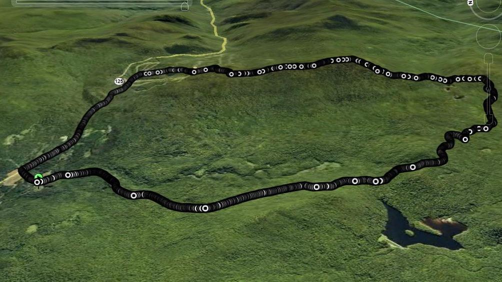
Setting off from my favorite running trailhead, the Brooks Road Trailhead (also known as the Chatfield Trailhead), located off of a short dirt road a mile or so below the Middlebury College Snow Bowl, I started up the comfortable climb on the dirt road. While this road is open to car traffic, I rarely see any motor vehicles on it. The road climbs steeply for the first mile and a half, rising about 400-500 feet rather abruptly, but climbs more gently most of the rest of the way to its end, 3.7 miles up into the mountains. When you get to the end of the road, follow the well worn path over the obvious footbridge over Sucker Brook, until you reach the Long Trail Spur trail on your left. Take this trail, which also climbs pretty gradually with a lot of easy running terrain for another mile or so, until you reach the Sucker Brook Shelter, found in a saddle in the Green Mountains known as “Romance Gap”. I met a small group of hikers, one of whom was a Long Trail through-hiker, and after exchanging pleasantries for a few minutes, headed up the hillside, and joined the Long Trail itself in a few minutes, turned left, and headed north towards Middlebury Gap.
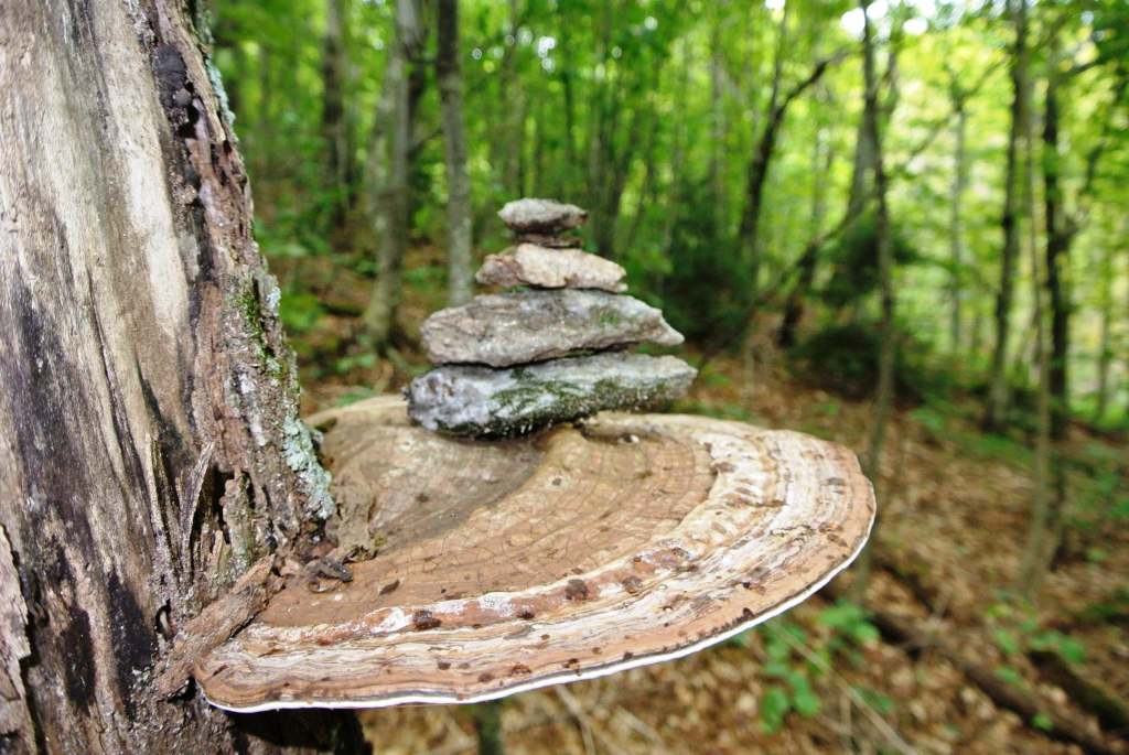
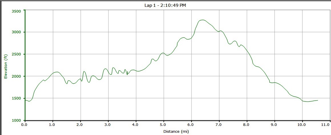
As expected, the running on the Long Trail was more technical than the rest of the run. As mountain ridge trails go, this was more runnable than most, with long sections of gradually climbing and descending dirt or mud path to run on. In the rockier sections, the running becomes more akin to skipping, with your feet doing all kinds of crazy things in order to maintain a decent speed! In sections where the climbing or descending got steeper, or potentially more slippery, I slowed to a fast hiking speed. This section of the Long Trail is not known for its sweeping vistas, although there were a few limited views through the trees in places. What I do love about this section are the more subtle sights one comes across when traipsing through the forest at around 3000 ft elevation. I have always been particularly fond of the shelf fungus growing out of the side of some of the older hardwoods, and one which I came across looked so sturdy that it was begging for something to display. So, I set up a small rock cairn on it, which will no doubt puzzle or amuse subsequent passersby if they have the presence of mind to look beyond their own boots or running shoes.
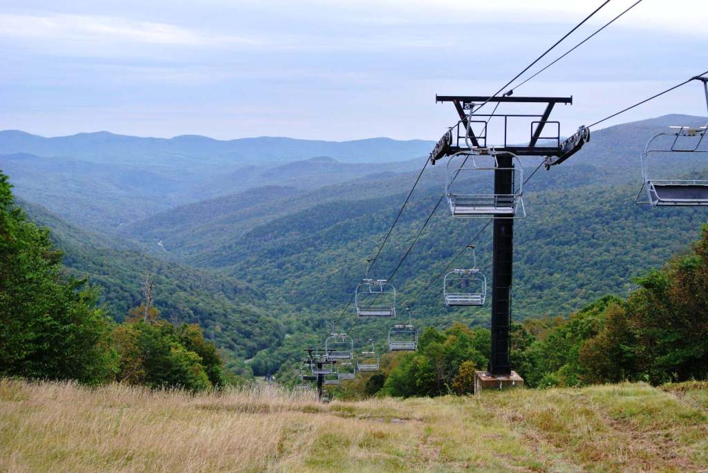
Not long after this, I reached the high point of the run, the summit of Worth Mountain (~3200 ft) and began the gradual undulating descent to the top of the Snow Bowl. I was amused to meet a hiker, who seemed so happy to get a signal on his cell phone that he couldn’t resist the temptation to check his facebook page. To each his own…. The wooden walkways signaled my approach to the Snow Bowl, and shortly thereafter, I broke out into the amazing view towards the east from the top of the Bailey Falls lift.
From here, I scrambled down the steeper upper sections of the Voter Trail at the Snow Bowl, named after Old Professor Perley Voter, one of my predecessors in the Chemistry Department at the college. He must have been great, as there is also a building named after him, Voter Hall! As I reached the bottom, I passed a fellow middle-aged trail runner on his way up the mountain, and after the mandatory exchange of complaints about our aging bodies, headed across the parking lot, and descended on Rt 125 to return to my car just as the drizzling rain started to get just a little bit heavier.
According to my GPS, this was a 10.5 mile run, with an 1800 foot ascent, probably closer to 2000 feet with the undulations along the way. Not a bad way to end the summer. Now, time to prepare for Monday classes……And bring on the Fall!
This is a great post, Jeff. It’s great to know about a “runnable” section of the LT. I’m curious as to what makes this your favorite running trailhead.
Good question Heather!
It is a favorite, as it is the start of two great routes into the Moosalamoo area – up the Brooks Road, from which you can branch out to Sugar Hill Reservoir, the Long Trail, and the Blueberry Hill trails – and the second route, along the Widow’s Clearing trail, which gets you to a lot of the lower altitude trails near the Goshen-Ripton Road, as well as Moosalamoo itself if you are more ambitious. Also, if you have a friend to work a car shuttle, any of the numerous point to point runs from this parking lot to the Falls of Lana Parking lot are great.