One of my regrets in my college career lies in one of my favorite courses, Intro to Geology. I took the class Pass/Fail, which left me with just enough knowledge to totally confuse the hell out of myself. I loved the class-I remember the labs most of all. Like going to the Lake Mansfield Trout Club, in Nebraska Notch at the base of Mount Mansfield, walking along the top of a lateral moraine in the woods, and making a hard left as the moraine turns into a terminal moraine.
I don’t remember much of the classwork, however, nor the tests. I still have the textbook we used, and I’ve been meaning to re-read it for the last 20 years since the class, as I found it fascinating. Geology is a language all its own, and not being fluent, or even knowing how to ask to use the bathroom, makes it difficult to read.
So Middlebury, be careful what you wish for, wanting a pass/fail option. Would I enjoy reading about geology if I had a stronger foundation in it, rather than skimming a class for an easy pass? I know I certainly would find it less frustrating, and the month plus gap in my blog writing would have been quite a bit shorter as well.
The other problem with geology, besides the language, is understanding time. We understand hours, minutes, days, weeks, even years, to a point. Humans can understand a generation or two, but go as far back as even 200 years, and time becomes irrelevant. How can we understand 4, 5, even 8 generations ago? I had a many greats-grandfather burned at the stake for witchcraft, but aside from creeping me out I can’t comprehend that far back.
And geology? Forget about it. The unit of time in geology is MYA, an abbreviation for Million Years Ago. The fossil record talks of rocks formed 200 million years ago, for example, but what does that mean? The Green Mountains were origniannly formed 450 MYA, but that’s as hard to grasp as 450 years ago, 70 years after Christopher Columbus ‘discovered’ the Americas.
I’ve planted many trees and shrubs here at Middlebury, and I love it, but planting rocks always seems to stick out in my mind. This fall I got to plant another. Dr. Peter Ryan, a professor of geology here at Middlebury (and excellent guest blogger) taught a course this summer for the alumni college called Vermont’s Geological Landscape: From Continental Collisions and Mountain Building to Groundwater and Streams. One of the field trips was to Pike Crushed Stone, up the road from Middlebury in New Haven, Vermont, and the source of much of our gray stone we use landscaping next to buildings on campus. While in the quarry they found a piece of rock with enough interest that Alum Paul Diette generously donated transporation to move said rock up to campus, where we ‘planted’ it on a leftover square of concrete up near Bicentennial Hall for future classes to admire.
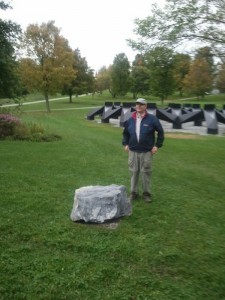
I’ve no idea why the concrete was there, but I think it was a piece left over from the old observatory that was up on that section of campus.
I thought the site appropriate, for several reasons. It’s proximity makes for easy teaching (not that the geology labs I’ve seen walking around have any fear of travel), but the a goal of Bicentennial Park is local trees and shrubs, so local rocks seem a good fit. I dream of filling the area with local rocks to sit upon, a nice contrast to Smog.
Paul has named the rock Diette-Ryan New Haven Iapetus Ordovician Seafloor, a pretty big name for a relatively small BFR, but was my lauching point into researching just exactly what this rock is. I’d always called this type of rock by it’s local name, Panton Stone. This limestone rock is used quite a bit locally in landscaping, as the pretty blue gray color and blocky fracturing make it natural for making stone walls, like a small wall north of Allen Hall next to the Atwater Dining plaza. Or better yet, look at the huge blocks of stone the next time you are out front of the Davis Family Library. Look close. You’ll notice fossils, lots of them, scattered throughout the stone, and this provides a convenient, if difficult way to age the rock.
Our new rock doesn’t have a lot of exposed fossils, and the couple showing only confused me further researching that. So instead I cheated, and went to the Vermont Geological Map to look up more specifically the type of rock, and a closer date.
As near as I can tell, this limestone is a ‘Beldens Member’ of Dolomite, dating it to about 480 MYA. The lack of many prominent fossils, probably lost in deformation and metamorphism, are good clue for age. The exposed ledge below Gifford Hall is probably in the same member family as this rock, writ large.
Vermont 480 MYA was a tropical paradise, like the present day Bahamas or Arabian Sea. Tectonic forces were pushing Vermont slowly to where we lie today, but back then Vermont was a shallow tropical sea,about 20-30 degrees south of the equator.
We sat in the Iapetus Ocean, forming part of a continent called Laurentia, comprising of our present North America Craton, combined with Greenland and parts of Scotland. (Iapetus was the father of Atlas in Greek myths, one of the original titans, and the Iapetus Ocean is the father of what we now call the Atlantic Ocean, named for Atlas.) Geologists have named this Ordovician time, in the Paleozoic era. The name comes from the British geologist Charles Lapworth, who in 1879 named the era for rocks found in Scotland.
Ordovician time was preceded by the Cambrian era, which saw life on earth diversify and explode into the many phyla we see today. Life in the Ordovician time continued to flourish, even as it was doomed at the end of the era in the Ordovician-Silurian Mass Extinction Event, the second largest (of five) such events we fellow earthlings have gone through.
Land wasn’t very interesting, mostly algae and mosses, but the calcite sea was an explosion of creatures, forming some of the earliest reefs. Around 480 MYA, when our rock was formed, the ocean was thought to be about 45 degrees Centigrade, limiting the amount and diversification of creatures, and therefore our fossils in the rock. The air cooled around 460 MYA, and more creatures arose, (http://www.anr.state.vt.us/dec/geo/foschamp.htm),filled with calcium rich creatures with hard exoskeletons, slowly dying to form what we now see as a hard limestone rock. Maybe we can see some foreshadowing, as carbon dioxide levels were 14-16 times higher in the atmosphere than present day, and high sea levels covered much of the continents in sea water. The globe was mostly ice free.
So for millions an millions of years, sea creatures were born, died, and fell to the shallow sea floor, slowly building the gray rock we move today.
Streaked throughout our rock are white lines, pure calcite precipitated out and laid down in cracks in the sea floor. A couple of fossils adorn it, although aren’t easily identifiable (know what they are? Post in the comments please!).
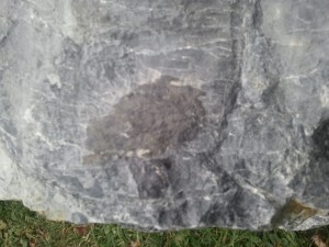
As well as a bump. The bump may be a piece of Chert, a poor cousin of flint, formed when silica replaces calcium carbonate.
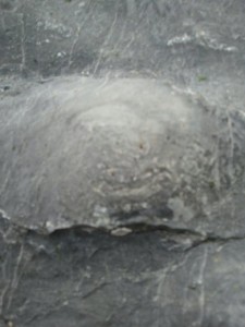 Fancier cousins include Opal, Agate, and Onyx, while our possible chert probably wouldn’t even make a good arrow head or ax, an early use for chert.
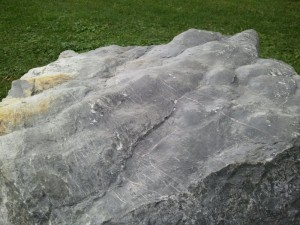
The best feature of the rock is the fossilized waves seen across the top. Imagine being a kid the the edge of the Iaptetus, one of those days when the tide was very low, and seeing how the waves formed ridges along the surface of the sand. The tide rises again, water levels return to normal, and a new shelf deposit of rock starts to form, hiding the wave marks, that are only exposed again by the quarrying process 480 million years in the future.
So, as near as we can tell, the rock dates to somewhere between 480-460 million years ago, but we are still stuck with the concept of time. That sounds like a long time ago, but so does breakfast at times. Paul put it best, giving a concrete time example to our rock, and a poetic end to the post.
Our sun rotates around the center of the Milky Way Galaxy, slowly, taking somewhere between 225-250 million years to make one rotation. Humans, as a species, have made 1/1250 of a trip. Our rock, two whole trips around.


You must be logged in to post a comment.