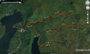
It seems like all of my posts this season have been describing runs in the Moosalamoo/Silver Lake region, and this posting will be no exception. On a cool, overcast Saturday morning, I joined up with a few running friends for another one of my favorite runs – the ascent up the North Branch Trail, beginning from the Falls of Lana parking lot, just south of Branbury State Park. So the three of us, accompanied by my friend’s labradoodle, Tizzy the Wonderdog, began our ascent on the service road. Just past the Falls of Lana, where the service road to Silver Lake makes a sharp switchback to the right, stay straight, taking the left turn over bridge, followed by a sharp right over the next few yards. This puts you on a trail, which if you remained on it, would bring you up to the Falls of Lana. At one point, you will have to vault over a fallen tree trunk, with a curious infinity sign painted on it, indicating that this segment of trail is also part of the course for Andy Weinberg’s legendary 888 km “Infinitus” event. But since we were feeling like mere mortals, we knew that this would be our only loop past this today, and after a few minutes, we came to the grassy clearing, where the actual North Branch trail veers off to the right.
Shortly after turning onto the trail we saw a few other runners and friends coming our way – they had apparently gotten a head start on us, and were already descending from the summit of Mt Moosalamoo. Nine years ago, when I started writing this blog, it was a rarity when I saw another runner on the trail, and now it is far more common, a testament to the increasing popularity of trail running in this part of Vermont, and the US as a whole. Over the next half mile or so, the climbing gets to be a little steep, requiring a few short sections with more hiking than running, and in no time at all, the stream that we crossed at the start of the trail was a few hundred feet below us. The trail in this section is well maintained, but narrow and rocky, and the brilliantly colored wet leaves on the ground covered some of the natural hazards make for slow going in sections, but as the leaves were thinning on the trees, at one point I noticed a substantial waterfall peeking out from behind the trunks, noting that I had only seen this before when it was early spring or late fall – the summer foliage always seems to obscure it!
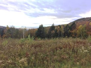
One can remain on the North Branch trail all the way to the Moosalamoo Campground, but on this run, I decided to take the short exit trail to bring us up to the little known Voter Brook overlook, at the end of the campground road, hoping to catch the fall scenery from this quiet little viewpoint. The combination of the cloudy weather, and the past peak foliage dimmed the splendor of the place, but only a little bit!
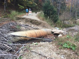
From here we decided to stay on the road back to the Moosalamoo Campground, and eventually the Ripton-Goshen road. Looking down at the road, which is very lightly used, it looked more like it was unused, as it was covered thickly with fresh leaves, and a few small washouts indicated why the last few hundred yards were not used. But still, the road, which was actually very pleasant running, was still covered by undisturbed leaves. In not long, we came to what seemed to be the cause of the road’s disuse – a fallen tree which would block traffic. This was still a little puzzling, as the Forest Service usually does a good job of taking care of fallen trees, even on little used roads, but after hopping over this modest impediment, I could see that the road was still unused. Eventually, we reached the sharp descent and turn in the road, where it normally passes over a small stream with a culvert under the road, and we finally saw what the real problem was – apparently, at some point in the year or so since I last passed this way, the road had washed out entirely, leaving a little bigger project to reopen car travel to the overlook. It apparently has been washed out for a while, as the local beavers had already created a dam across the culvert.
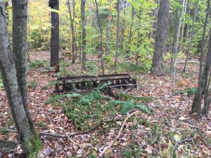
From here we continued on the now gravel and dirt road, sans leaves, until we reached the Ripton-Goshen road, where we took a right, and after a somewhat surprisingly tough climb to the high point of the run, took the snowmobile trail to the right, where you see the forest service gate. This begins a long gradual ascent, a nice respite after all the climbing to get up here. The main snowmobile trail is usually easy to pick out, but some recent small scale lumbering activity had made a previously “minor” trail look more substantial, so we got off course for a short while until we realized that this side trail was getting faint. It was interesting to see a rusted out old plow in the middle of what appeared to be probably a 50 year old forest – it has clearly been a long time since this land was cleared for a farm!
Finding our way back to the main trail, it eventually bottomed out over a well-built snowmobile bridge, before a short steep climb up to the Silver Lake forest service road, well above the lake. Going straight here would have been the shortest way back to our cars, but instead we took the left turn, leading to an undulating climb up to the Goshen Silver Lake trailhead, which was nearly empty. Getting back on true single track, we followed the descent to the Leicester Hollow trail, and followed it back to the “beach”, which not surprisingly, was empty, although we did see some people kayaking out on the always quiet lake. Finishing the run with the last mile and a half descent to the parking lot, passing quite a few hikers out for what will probably be their last hike of the season, brought the run to its conclusion. This ended up being a 10.5 mile run, with a solid 1500 foot climb and descent, although a lot of it was more undulating than grinding.


