Ok, so some of you must be asking “What the heck is The Blerch?”
The Blerch is a character, created by the author and cartoonist known as “The Oatmeal”, who has described The Blerch in the following words:
“Marathon runners often describe a phenomenon known as “hitting the wall.” They refer to ‘the wall” as the point in a race when they feel physically and emotionally defeated.
I do not believe in the wall. I believe in The Blerch. The Blerch is a fat little cherub who follows me when I run. He is a wretched, lazy beast. He tells me to slow down, to walk, to quit.
“Blerch” is the sound food makes when it is squeezed from a tube. “Blerch” is the shape of my tummy after a huge meal. If I am sedentary at a time when I have zero excuse for being sedentary, I call this “blerching.” The Blerch represents all forms of gluttony, apathy, and indifference that plague my life.
The Blerch always seems to appear in my life over the holidays – too much good food, too much good wine, and too much time on the road or in the homes of my extended family can make for a relaxing holiday, but not one in which I get much running in. “Its too cold outside Jeff – you don’t want to go out there”, or “Gee that football game, the Dingleberry Bowl between Okoboji State and Turkey Tech sure sounds good”, or “I shouldn’t run right after eating – where are the Christmas cookies?”. Yup – that’s the Blerch talking!
A few days ago, one of my running friends in Middlebury Trail Enthusiasts announced a run up, over and back on my old favorite, Snake Mountain, for this Saturday morning, and this sounded like a great way to jump start my running legs after the lethargy of the holidays. So, when my alarm went off at 7 am on a Saturday morning…..I hit the snooze button. Damn that Blerch! 10 minutes later, as the alarm resumed its insistent buzz, I realized that it was time to silence The Blerch along with the alarm, so I got up and poured a cup of coffee. Then, I looked at the thermometer, and it read “9 degrees”. Ugh – its too cold out there, but as the sun rises it will warm up, right? So I had my breakfast, and drank a few more cups of coffee, and when the time came at 8:30 am to drive off to the Snake Mt. trailhead on the west side of the mountain, I looked at the thermo-tormentor, and it let me know that the meager rays of sun had raised the temperature all the way up to 11 degrees. At least at this point, I realized I had drunk too much coffee to go back to bed, so off to the trailhead I went, donning about seven layers of clothing.
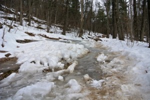
My mood improved considerably upon seeing four other runners ready to go at the start of the run. We had been forewarned to wear some sort of spikes on our shoes given the icing on the trails, so I brought my Asics Gel Arctic shoes – basically a normal running shoes with short spikes in the soles, for the winter ascent. The rest of the group had slip on spikes, known as MICROspikes, which they wore over their running shoes, and looked like they might offer even better grip. Sure enough, as we set off up the trail, while my shoes did well on the old styrofoam snow, frozen mud, and hard packed trail snow, they offered no grip whatsoever on the brief but challenging sections where the trail was essentially a frozen waterfall.
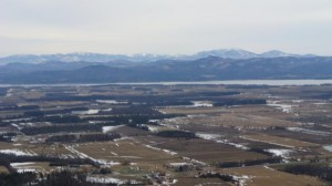
As a result, my pace was much slower than usual, but nobody else was running much faster. Achieving the summit on this bitter cold morning, which seemed much more bearable after climbing for over two miles, we were treated to some amazing Adirondack views. I have always felt that if you squint your eyes just a little while looking west, you can almost convince yourself that our winter views of the ‘Dacks look an awful lot like views of the Front Range from Denver.
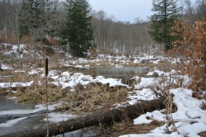
After ascending from the more heavily hiked west side trail, we decided to descend down the east side. To get to this trail, you have to pretty much know where it is, as it is an unmarked trail. About one third of the way down the mountain, the west side trail takes a sharp, steeply descending right hand turn, and the east side trail is achieved if you go straight at this point. If you have never hiked this trail before, I would recommend ascending from the east side parking lot on Snake Mountain Road, so you can see where the trails meet. Given the lighter use of the east side trail, the snow was not as compacted as it was on the much icier west side, making for an easier descent, passing by some nicely terraced beaver ponds.
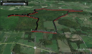
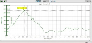
When we reached the east side parking lot, we had a decision to make: I was not looking forward to the climb back on the trails, and back down the west side, as my footing was much poorer than the others’ and I was not enthused about sliding down the mountain on a frozen incline. I knew there was a way to circle back to our parked cars by taking the Forest Road, a road which ran over the southern shoulder of Snake Mountain, but I did not have a clear idea what the mileage of this route would be. Some members of the group suspected that my mileage estimates might be a bit on the short side, and were not up for the potential of a significantly longer run. So, we ended up splitting the group- after all, this is supposed to be fun – and some went back up the mountain, while a few of us chose the road return, heading south on Snake Mt. Road, west on the climb over Forest Road, and then taking the right turn onto Mountain St. extension to return to our vehicles. Other than occasionally choking on the dust churned up by passing cars, this was actually a nice road run with views to the east and to the west at various points along the way. Although my initial conservative estimate of the distance was indeed shy of the actual mileage by about a mile and a half, I had not missed by as much as some of my running partners feared. The two groups met back at the parking lot within a few minutes of each other, and our version of the run worked out to almost exactly 10 miles, with the about 1000 ft climb up the mountain.
Happy New Year, and Death to the Blerch! (although he is kind of cute…..)

