On a cool mid-October day, I realized that it had been a few weeks since my last blog posting, so I thought about some good possible runs, and went online to perform a little cleanup to this blog. Then I realized that this was going to be my 100th posting! Should I come up with something particularly epic, or maybe even a little bit dangerous? Nahhhhh…. Instead, I decided to retrace the steps of the same run that I did for my very first posting, way back in June 2009. So, here goes – my inaugural run for “The Middlebury Trailrunner”, the run from the Falls of Lana/Silver Lake trailhead, up past Silver Lake to the Goshen Trailhead on the hillside above the lake, and back. I have done more runs from this trailhead than from any other starting point, but had not written up a new posting on this identical route, although I have run it countless times. Whilethis is probably not a recommended for for running neophytes, it is an appropriate, adventurous run for folks for whom road 10K’s are “about right”, but want to start exploring more adventurous terrain. This particular route has some significant hill climbing, but is primarily on double track forest service roads (only open to maintenance vehicles), so it is a great place for decent runners to start exploring trails. Kind of like me, 5 years ago.
A lot has changed in the last 5 years, at least as far as my running goes. When I first blogged this run, I thought of this as a pretty adventurous route, between the significant climbing, and its backcountry feel in a very scenic part of Addison County. Regular readers will note that while I do continue to weave in runs of moderate length, my longer runs have gotten…well….longer! I have also become more adventurous in my choice of new routes, with my attitude to new routes evolving from “Gee, I would like to know where that trail goes, so I can give it a try”, to “I bet that trail goes somewhere new, let me check my map”, to “OK – there is a path I have never noticed before, here goes!”. Adventure follows! Trailrunning has also rejuvenated my running, as I have found that I can go out on longer runs with greatly diminished frequency of injuries. This is key for middle-aged athletes, as every ache and pain becomes an excuse to not run, and a gradual acquiescence to the inevitability of old age – prematurely. Trail running puts one in the situation where every footfall is unique, and that fact, combined with its slower pace, minimizes the repetitive use injuries so common in distance runners. The other wonderful discovery I have made is that a steady diet of trail running on challenging terrain, with a longer runs every few weeks, is great preparation for marathon running, an empowering aspect of running which I had given up on for close to 20 years due to frequent annoying injuries.
Now – on to the run! When I first blogged this run 5 years ago, it was an early summer run in June of 2009, and the run reflected that season. This time? Mid-October, while still lovely, at least this year, is the very end of fall foliage, and the summer resort around Lake Dunmore is mostly shut down for the season. The Kampersville Squirrel? Still there, but she somehow looks a little creepier on a grey day. As I drove around the shoreline towards Branbury State Park, I also noticed a lot of “For Sale” signs in front of lakeside homes. I suppose their owners wanted one last summer on its shores before starting the process of turning over their summer haven to new owners? I also noticed that, at least on this blustery Sunday afternoon, that there were no cars or beachgoers along the shoreline of the state park. However, I was pleasantly surprised to see that the Falls of Lana trailhead, just south of Branbury, was pretty close to full. I guess trailrunners and hikers are a hardier sort than beach folks? Apparently, although I suspect some Maine coast beachcombers would beg to differ, or even those who brave the Atlantic coasts further south in the off-season.
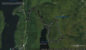
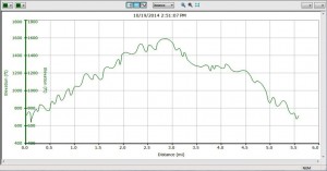
I am not going to spend a lot of time describing the details of the route – it is pretty easy to follow. Run up the forest service road departing from the Lake Road a hundred yards or so south of the parking lot, and follow its switchbacks all the way to Silver Lake, at about a mile and a half, and continue up the hill above Silver Lake on this road until you reach the Goshen trailhead , at which point you follow the trail descending back to Silver Lake, reaching the lakeside Leicester Hollow Trail, where you take a right turn. After slightly less than a half mile on this trail, take the left turn, following the campground sign pointing to the picnic area, which will bring you to the Silver Lake “beach” and then back to the original road on which you initially climbed, where you complete your descent back to your waiting car, for about a 5.6 mile run, with about 800 feet of climbing and descent.
That said, since I have run this trail countless times, but never at this specific time of the year (past-peak foliage, segueing into stick season), I made a point to look for things I had never noted before. So, for the rest of this posting, I will share these bits of minutiae. So – here goes!
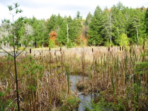
1. A little over a mile into the run, if you look to your left through the trees, you will notice what looks like a small body of water to your left. I had always called this “Moose Pond” in my mind, but had never done the very short bushwack to actually stand at its shores. I associated it with moose, as I had envisioned it as a great place to see a moose someday. I finally took a few moments to actually step onto its shore, and while moose sightings continue to evade me when I am running, I realized that my name was a misnomer: This is a rather substantial beaver pond! If you look at the picture carefully, you will see the beaver hut in the middle of the pond. There is also a rather substantial beaver dam, just to the right of the frame of this photo.
2. When you get to the shores of Silver Lake, you will notice a campsite for a campground host to your left. Over the last few years, there was an elderly gentleman who filled this role, and while I stopped to chat with him a few times, I never inquired as to his name. He was not there this summer, and for most of the summer, the campground host camp site was empty. I hope he is in good health? That said, I had always romanticized he notion of spending a summer in the forest, away from the comforts of home. On this run, I took the time to look around the empty site, and found its dirty little secret – it has electrical power. Set me up in the campground, and let me rock tunes on my portable electronic devices!
3. Much of the road ascent during the summer has a tunnel-like feel. The overhanging foliage blocks most views, and keeps the road more or less permanently in the shade. On this run, with most of the trees bereft of leaves at the higher elevations, rather expansive views opened up!
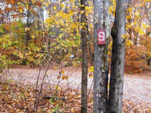
4. As I approached the Goshen parking lot at the end of my ascent, I noticed an old wooden sign, with the number 9 painted on it. Does anyone have any idea what this means? It was not one of the blue signs with yellow numbers, which the Blueberry Hill Ski Touring Center uses to mark its trails. Nor was it one of the far more polished numerical signs which grace the shores of Silver Lake, which I assume accompany a pamphlet which I have never seen, probably with a name like “Groovy Trees of Silver Lake”. Maybe the Number 9 was referring to one of my favorite summer microbrews? I doubt it!
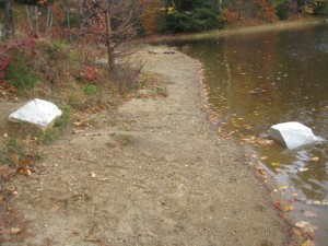
5. There are a few well placed marble blocks on the shoreline of Silver Lake. I have never noticed these before, and I can only assume that these remain from the old Silver Lake Hotel. If you would like to learn more about this long gone hotel, you should purchase “Leicester Vermont’s Silver Lake — Beyond the Myths” By William Powers. You can find it on Amazon, or at the Sheldon Museum!
I am going to finish with a few observations I have made associated with management of this blog, as I have learned a few interesting things about how the internet really works through the use of WordPress (the software I use for this blog) analytics.
1. About 90% of the information transferred on the web is total spam. We are all familiar with the junk mail that fills our inboxes, but the amount that assaults this blog, in an attempt to post links leading to god knows where when clicked, blows my mind. I probably see 10,000 spam messages for every real reader response. Fortunately, the brilliant software which the WordPress programmers have added to the blogging software is ruthlessly efficient at blocking this, so it only takes me a few moments each week to delete, and it never clogs up the blog comments. For some reason, spam touting the wonders of Luis Vuitton handbags, and Adam and Eve sex toys seem to be the worst offenders. I have also noticed that every time I mention my Garmin GPS watch, I get inundated with Garmin spam for a week or two. Yes, the web is dominated by spam bots!
2. One of my very first posts, describing a run I did in Bristol entitled “Things to do in Bristol when you are bored” seems to get a lot of hits due to people Googling the terms “bored in Bristol”. For the life of me, I cannot figure out why almost every day, one or two people somewhere in the world google “bored in Bristol” and end up on my blog. I have googled these terms, and seen nothing of note. I wondered at one point if my mischievous teenage daughter was messing with me, but she claims innocence.
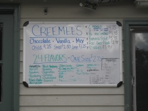
When I first posted this run, I also mentioned the ready availability of creemees and other frozen treats at the Kampersville Deli. Alas, this summer attraction is also closed for the season, but its whiteboard price list is still inviting. I wonder if the price list will still be there in the spring?
So now, I have to ask my readers (both of you?)- Do you know of any good treasure troves for trail traversing which I (we) might explore at some point? I have a few good ideas of new places in the vicinity to explore, but am always looking for some new suggestions. Feel free to respond with any of your inspirations!
Cheers, and hope to see you at post #200
Jeff
