The Mad River Valley is where some of my extended family lives, and while not quite part of Addison County,it is another great place for trail running. Even for those without lodging in the area, it is only an hour away, and a worthwhile place to go for a run for a nice change of pace. I was visiting “over the mountains” this weekend, and had the time and energy for a more challenging run, so considered some of the local options for true mountain running. I know from past experience that all ski areas have service roads leading to their summits, and if these roads proceed up novice, aka “green circle” trails, while they may be relentless, they are usually at a low enough incline for extended runs without breaking into a walk too often. If the service road proceeds up an intermediate, or “blue square” trail, you are probably going to be doing a fair amount of power hiking rather than running, no matter how easy the trail seems to be when descending in the winter. A few years ago, I described the relatively short run up the Middlebury College Snow Bowl, as well as the much more challenging ascent to just below the summit of Mt. Mansfield in “The Race to the Top of Vermont”.
Remembering how much fun I had a few years ago, in the locally run Race to the Top of Vermont, I was initially enthused to see that a new race, involving an ascent of Mt. Ellen, one of the highest peaks in the state, and the northernmost summit of the Sugarbush Ski Area, was happening this September. Reading the details of the race, however, my interest plummeted like an out of control runner on a steep downhill. Unlike most of the races in VT, this was part of a larger, national series of races, and is part of, what to me at least, is a disturbing trend in competitive athletics. Most races in VT are locally run, and a modest cost to competitors, and profits are usually turned over to charity. These national race series are almost always “for profit”, very expensive, and only turn over a tiny percentage of their profits to charities. Some of these series, like the Ragnar Relay running series have developed a reputation for rapaciously supplanting previously existing races. Others, like the now famous “Tough Mudder” races have arisen from the business plans of Harvard MBA’s rather than any innate love of sport or charity. In any case, this “O2X” race series, which includes a run up Mt Ellen in its race series wants 120 bucks to race! I don’t mind paying more for a race if I can see where the money has to go – marathons take a ton of support over the course of 7 hours or more, and often include the closure of many city streets. The obstacle course races of the Tough Mudder genre, while not my cup of tea, at least have a lot of setup to do before each race. This O2X series brags that mother nature is providing all the obstacles, which is of course a brilliant business plan, which combined with their commitment to give a whopping 1% to charity sounds like it will result in some happy young millionaire race organizers! To put this entry fee in perspective, the Race to the Top of Vermont, which raises funds for the Catamount Trail, charges $30-$70 for its entry fees, and another mountain ascent race just up the road at Mad River Glen charges $25! Even the Jay Peak 50K Ultramarathon, with two ascents of Jay Peak, and which has far more organizational challenges due to its length and terrain, charges only $85!
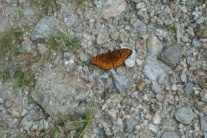
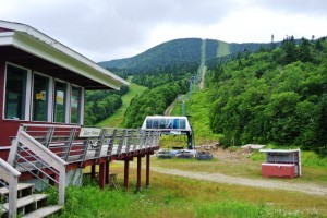
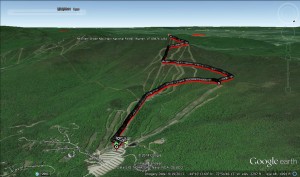
After reading of this attempt to charge an exorbitant fee to run up a mountain, which due to its status as national forest is actually free to access, I thought I would describe a fun running route up the mountain. I parked my car at the nearly empty Mt. Ellen parking lot and took a look up the mountain, and realized that I had a fair bit of challenge ahead of me. The service road under the Green Mountain Express chairlift, just to the left of the base lodge looking uphill was where I began my ascent. For the first half mile of so, the road follows what is the easiest ski trail on the mountain, making it a merely “tough” ascent, and after it reached the base of the North Ridge chair ascended more steeply to the right. I still found this section runnable, but at a very slow, stutter-step stride. While this section of running was labelled as novice terrain in the ski trail map, it was certainly much steeper than a typical bunny slope. Part way up this section, the service road split, half bearing left up comparably steep terrain which I suspected would blow out my quads pretty quickly, or a more gentle ascent to the right, which in the ski season would be thought of as a crossover trail. I took the path of least resistance, as I really did want to run. All along this section, I was accompanied by a retinue of lovely orange butterflies, and with a little patience I coaxed one into sitting still long enough to get her picture taken.
This segment brought me the the far north (uphill runner’s right) of the ski area at the top of the Inverness Chair, about 1000 vertical feet above the parking lot already, but with a long way still to go. Another crossover trail was found with a sharp left turn, crisscrossing me back under the “Exterminator” trail, the North Ridge Chair, and brought me to what is usually thought of by skiers as the point about halfway up the mountain, the small restaurant at the end of the Green Mountain Chair called “The Glen House”.
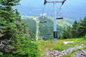
I felt pretty accomplished at this point, but looking straight up, I realized the biggest challenges were still ahead of me. Going into this run, I had hoped that the service road to the summit would follow the gentle “Rim Run” trail to my left, but instead followed the much steeper, truly intermediate trail directly under the Summit Chair. I guess it makes sense in retrospect that the service road would actually follow the chairlift it aims to service? This next segment, from here, to the top of the North Ridge Chair, was the steepest part of the ascent, and such, I was only able to maintain a running stride about half of the time. Upon reaching the top of the North Ridge chair, I turned to the left for the last ascent to the summit along the north ridge of Mt Ellen, and at first thought that I was in for a tough crawl up what looked like a too-steep-to-to run segment.
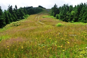
So, I did what I had to do, I took a break, and took some pictures of the wildflowers, mostly daisies and another yellow flower akin to dandelions. Resuming my run after this brief break, I found the running easier than expected, and only slowed down for a few short scrambles over ledgy rock sections. Reaching the summit, I chatted for a few minutes with a gentleman who had hiked up and had been following my progress from his perch at the top of the mountain.
After a few minutes of enjoying the summit scenery, I retraced my run back to my car waiting below, once again being careful to moderate my speed so that I would still have fully operational quads the next day, and I can say now, writing this up on Sunday, that I was successful in that! Also, the footing can be a little bit more difficult with loose rocks on the descent, so this gave me another good reason to check my speed.
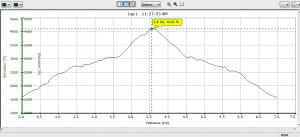
Overall, this was some pretty cool terrain, and a good challenge for mountain runners – this route took about two hours round trip, and covered 7 miles, with 2500+ ft of climbing and descent. The lesson to today’s run? You would have to be crazy to pay all that money ($120) to access terrain and scenery which is free, and if you want to enjoy the challenges of a hill climb race, there are plenty of other options which are convenient, charitable, keep your money in VT, and leave you with plenty of money for beers – heck for a steak dinner – with your running friends.
