One of my all-time favorite short trail runs is the popular dash up to the summit of Snake Mountain, with its panoramic views to of Lake Champlain and the Adirondacks to the west. Each September, I also like to present an easily accessible run for the benefit of Middlebury College freshman who might be looking for nearby runs or hikes that can be reached quickly from campus. While this trailhead requires (for most people) a short drive, there are enough snazzy SUV’s on campus (and we aren’t talking 10-year old Dodge pickup trucks -go Lexus!) that opportunities for transportation are not hard to come by. I have blogged runs up this mountain a few times in the past. From the well known western route, I have described the run under both midsummer conditions, as well as during Mud Season. I have also described the lesser known trail ascending Snake Mountain from the east side. Nonetheless, there were still some trails on this well trammeled mountain which I have not described, or even explored, and so I thought it would be fun to make them part of a new entry.
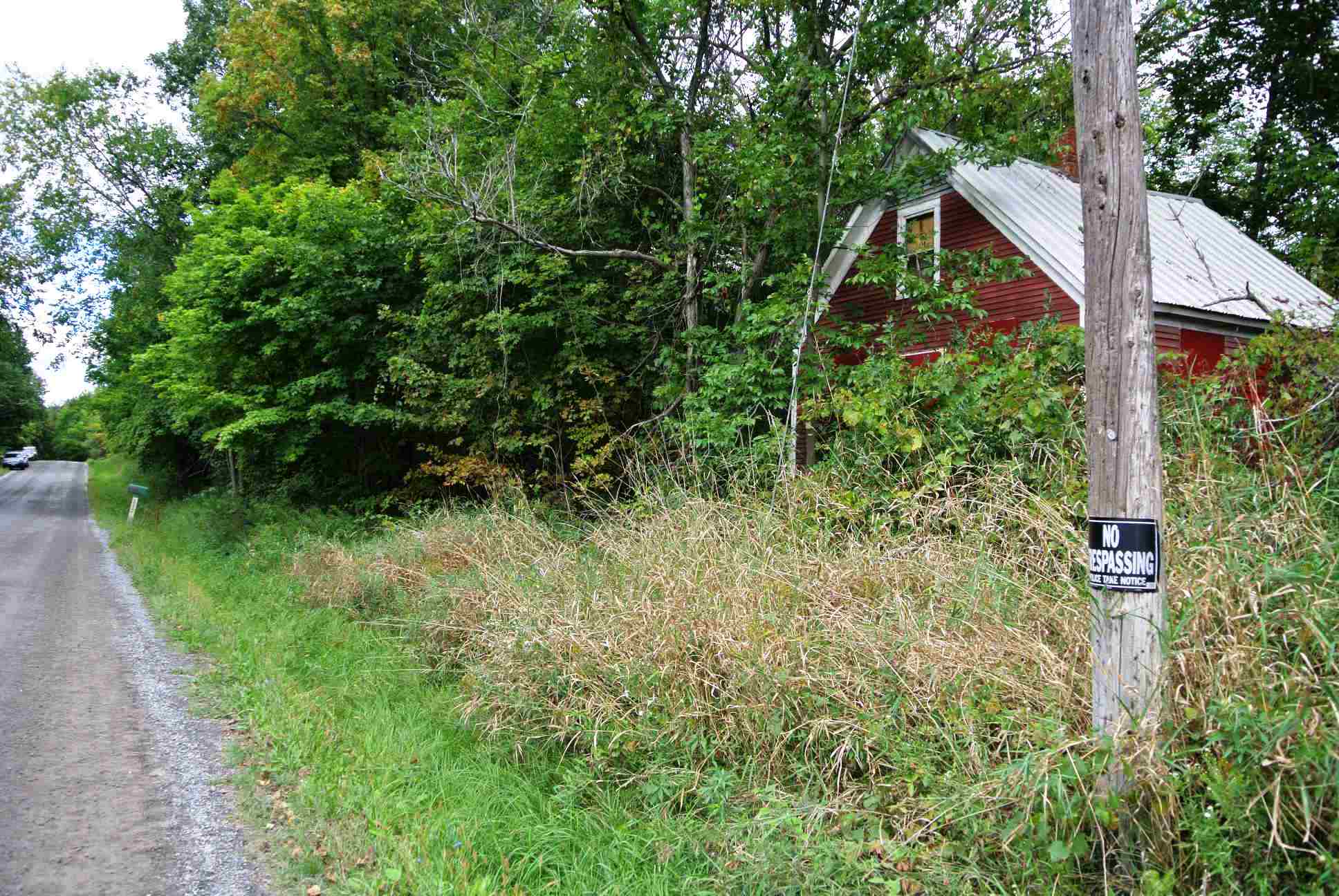
An old schoolhouse near Snake Mt.?
Rather than describe in detail the driving route to the trailhead, I will refer my readers to a previous posting with detailed instructions on how to get there. Setting off from the parking lot, and shortly before heading up the mountain trail, I noticed that the old building across from the end of Wilmarth Road at the trailhead had been repainted a bright red, and with this new paint job, it looked a lot like an old one-room schoolhouse. I have never thought of this abandoned building in this regard, but now I wonder if it may be an old schoolhouse. Does anyone know of the original purpose of this building?
The first section of the run involves a straightforward run up the broad trail, which was dry on this run, but can be a pretty major quagmire in the spring. As this section of the trail ended, it reached a “T”in the trail. It is pretty obvious to that a left turn takes you up towards the summit, but I have always wondered where I would end up if I were to take the right fork? Maybe on the way down? Staying on the obvious trail, through a series of switchbacks gets you to the main summit after about 2 miles. Many visiters to this summit have been under the impression that the large concrete slab at the summit is left over from the former small summit hotel which operated around the turn of the 20th century. This slab is actually of more recent origin, although I don’t know the exact decade in which it was built. It apparently is the result of someone’s aborted attempt to build a home on the summit, and the real foundations of the hotel can be found not far from this viewpoint in the woods.

Paper Mill in the distance
Most hikers and runners don’t come up here for the history, however. They come up here for the spectacular views. Even though the day of this run was pretty cloudy, the views were still excellent – I could easily make out the smoke from the Ticonderoga Paper Mill, about 15 miles away.
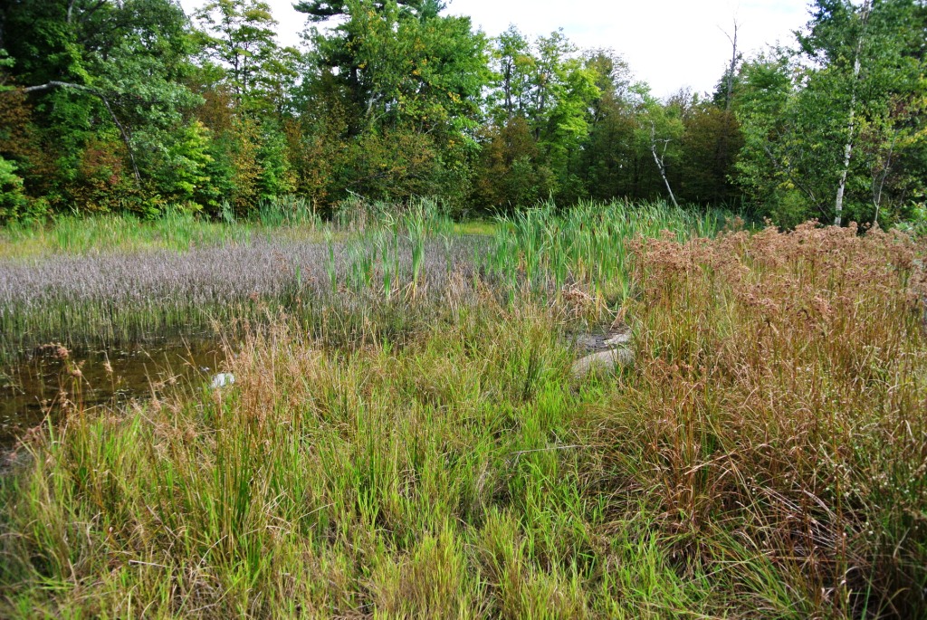
Unlike my previously blogged runs on this small summit, I decided to take a different route on the way down. So, on this run, I took the first obvious right turn on the descent, and in a few short minutes arrived at the other, less frequently visited vista. During some summers, this other viewpoint has been closed due to peregrine falcon nesting, but apparently there wasn’t a nesting pair there this last summer. This “South Summit” (OK – stretching the Everest analogy here a little bit too much?) also has another curious feature. Directly behind the rock where most hikers enjoy the view, there is what appears to be a small marshy pond. What most people don’t know is that this is actually a man-made pond which was created to provide swimming opportunities for the guests of the long gone summit hotel! It’s anthropogenic origins are more obvious if you notice the man-made earthen berm along the east side of the pond. I might also add that this pond, now rather shallow and mucky, shows no sign of whatever appeal it might once have had to summit visitors!
Summit Swimming Hole
Continuing on, the descent from this summit takes you down a trail which is steeper and narrower than the ascending trail, and eventually returns you to the main trail. At this point, you can simply retrace your steps to complete a 4 mile run, but as alluded to earlier in the posting, I decided to explore the continuation of the summit trail which goes straight, where most hikers and runners turn right. Not having the slightest idea where I might turn up, I headed down this trail, which eventually brought me into a lovely meadow, and shortly thereafter, to the side of the road known as Mountain Street Extension, where I took a right turn, followed about a half mile later by another right turn which returned me to my car, adding an additional mile to the run. The five mile run, combined with nearly a thousand feet of ascent and descent makes for a fun, and pretty intense mountain run. But remember, like a lot of fun challenges, it is only hard the first time!
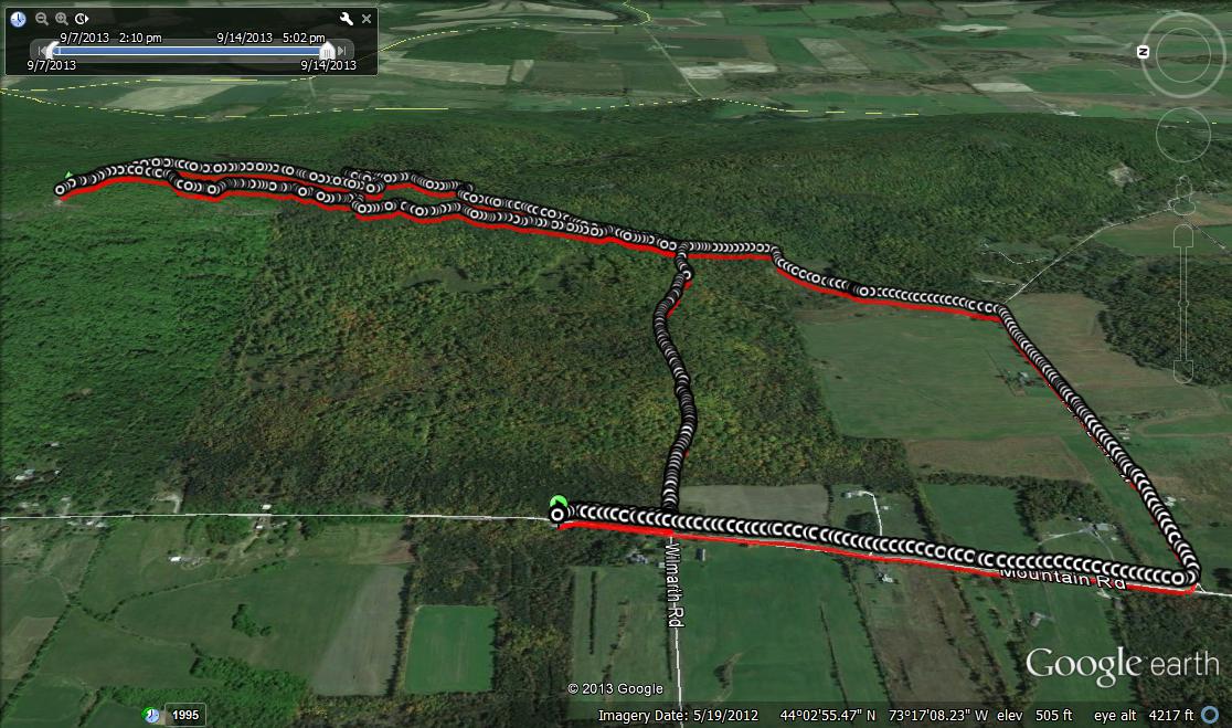
google earth of the Snake Mountain route.
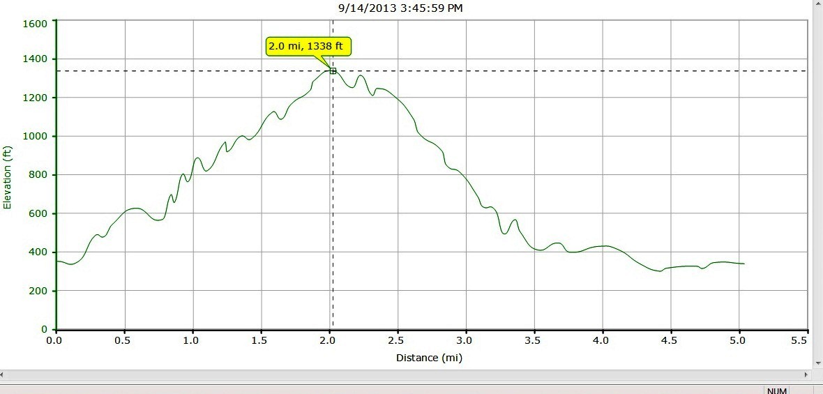
Altitude and Mileage