Being part of the snow removal crew at Middlebury, it’s a little disconcerting to awaken on a lazy Sunday morning, look outside the window, and see it snowing like the dickens. So I go downstairs, start the coffee (priorities), boot the computer, and look at the Old Chapel Web Cam. Phew, not snowing on campus. Fooled by lake effect snow again.
Fortunately, we don’t live in Buffalo, but we certainly do get lake effect snow in the Champlain Valley. Lake Champlain is deceiving, as it is only 12 miles wide at the widest point, and much less wide down our way. It is, however, 125 miles long, north to south. (While we’re at it, average depth is 65 feet, with the deepest part a whopping 400 feet. That’s down where I used to live in Charlotte, and I can remember getting the heebies cross country skiing over that area when the lake completely froze one year. The lake is about 700 square miles). Lake Effectsnow requires several meteorological items to align, the major two being fetch and temperature. Fetch is simply the wind blowing across the lake, picking up moisture. The fetch needs to be at least 100 km, so the wind on Lake Champlain needs to be from the NNW, which it was this morning.

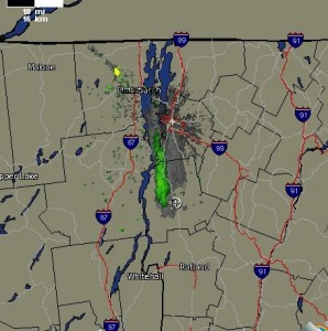
- Lake Effect Snow Radar Map
The temperature is the other major factor. The air temperature at altitude (850 mb temp, roughly 1500 feet up) needs to be 15 degrees celsius less than the lake temp. The air temperature this morning was about 15 degrees, and the lake was a balmy 43. So, as you can see on the radar map, no snow at Middlebury, where the white circle is, while at my house, due west of Middlebury, we are seeing snow.