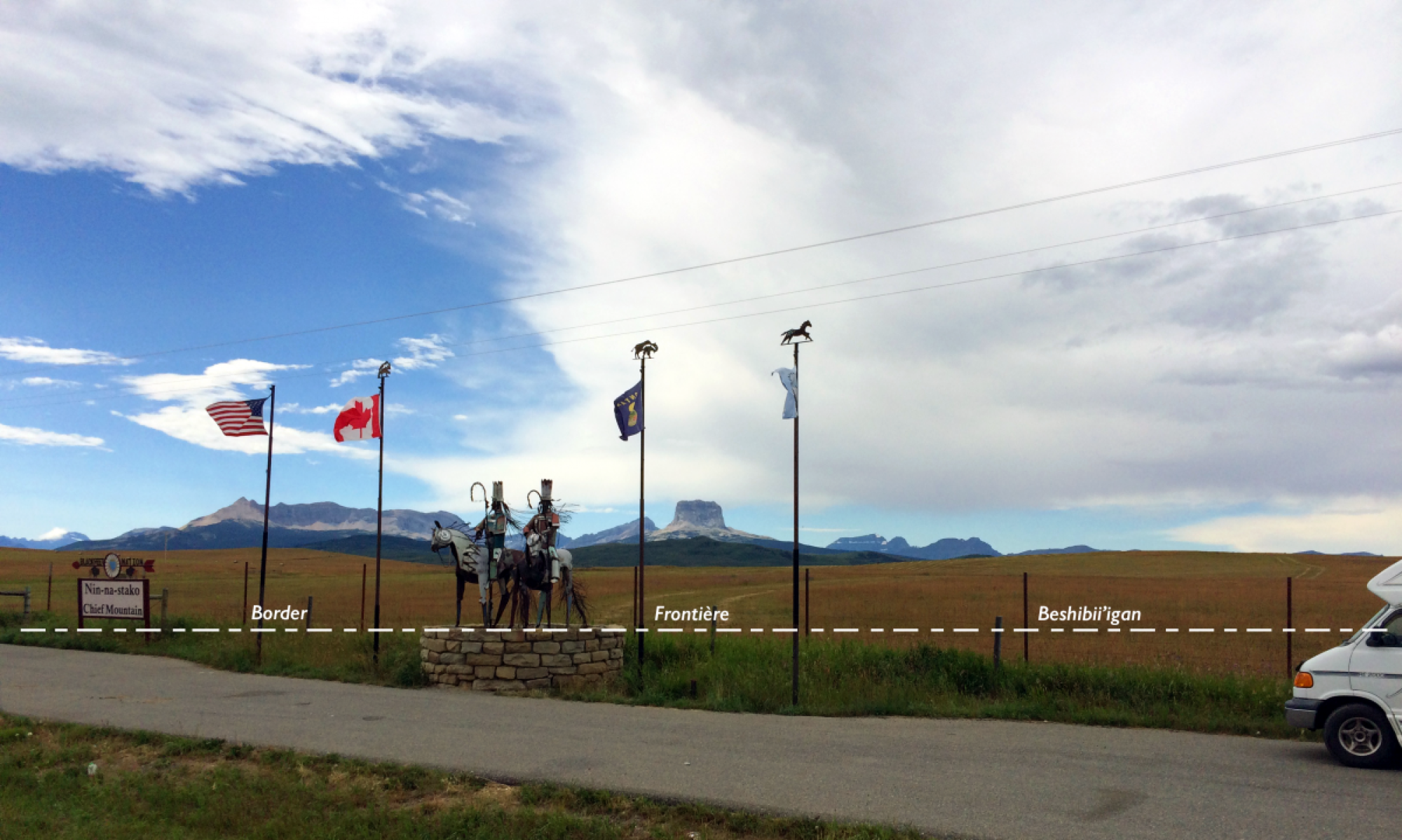
The Jay Treaty of 1794 guarantees Native nations free passage and trade across the US-Canada border, but stricter border controls after 9/11, have drastically curtailed Indian mobility. Where members of the more than 50 sovereign indigenous communities could once simply walk, drive or paddle across the border to see relatives, hunt, fish, gather wild rice or berries, visit burial grounds, collect holy medicine, or attend spiritual gatherings, there are now sensors, drone surveillance, checkpoints, fences and other obstacles.
Most Americans or Canadians are blissfully unaware of the divisive effect of the border on Indian rights and rites or of the existence of traditional native homelands outside their reservations. Government publications in the United States and Canada confound this ignorance because they only cover their respective ‘national” territories, which they are eager to demarcate as separate and exclusive entities.
The project seeks to break the silence that surrounds native nations living in the borderlands through this multi-media website. A multi-media website with numerous maps is preferable to a traditional atlas or illustrated book as an instrument for outreach and Indigenous empowerment because it: (1) allows for a much greater range of visualizations and media; (2) can be easily updated to reflect the latest information or changing views of the Native communities it seeks to represent; (3) is free and thus ensures the widest possible access—a key issue given widespread poverty among native nations as a result centuries of domination; (4) is not subject to the commercial interests of publishers; (5) can be sued as a teaching tool as illustrated in the pedagogy section; (6) should help the assertion of Indigenous rights since map-based technologies have an aura of being scientific and authoritative.
Fieldwork has played a central and essential role in the creation of the website given the astonishing lack of information about Indigenous nations astride the US-Canada border. My wife Patricia, who is an enrolled member of the Sault Ste Marie Tribe of Chippewa Indians, and I have been traveling the entire length of the US-Canada border from the Atlantic to the Pacific coasts and up to Alaska and Yukon in a camper van to learn from the Indigenous peoples in these borderlands. I have been documenting our interactions with people and landscapes in writing, audio recordings, photographs and video, while Patricia is expressing her experiences in poetry and art.
The guiding principle for our information gathering is minaadendamowin, which means ‘respect’ in the Anishinaabe language. When my wife and I spent three months with her tribe in Sault Ste Marie in 2010, we heard this word over and over. It represents a universal concept: respect for the Elder, respect for the earth, respect for all living beings, respect for the land. The same respect informs our interaction with Native borderland communities: specific and personal information we gathered from them will be presented to them for review before it is made public on the website. The contact page on the website also gives Native nations the opportunity to make suggestions or ask for changes.
Indigenous conceptions of place differ markedly from Western notions of territory and we strive to offer a respectful presentation of these alternative visions. Native peoples have a deep and experiential connection to their lands that is expressed through stories passed down the generations, symbolic practices, ceremonies, performances, and spiritual rites; Indigenous peoples are situated in place. By contrast, American and Canadian ideas about the land are abstract and rational and land is considered a commodity that can be owned, divided into parcels, and sold. The website’s goal is to document Indigenous views as well as US and Canadian or “Western” views. Given the fact that tribes claim sovereignty over specific territories, operate businesses, and have adopted some Western governmental structures and that Americans and Canadians also cherish attachment to places, Native and non-native conceptions are not viewed as exclusive, but as being in dialogue with each other.
Terms and names for indigenous peoples and places have a horrid history that reflect centuries of oppression and prejudice. Our goal is to be as respectful as possible and to identify Native peoples with their original names. An example would be ‘Anishnaabe’ instead of the terms given by settler colonialists: ‘Chippewa’ (often used in the United States) or’ Ojibwe’ (mainly used in Canada). Yet, many nations still use Chippewa or Ojibwe in their official names. This case shows that terminology poses tremendous challenges. It is highly contested, even among Native nations on either side of the international boundary. In the United States, Native people have increasingly embraced the term ‘Indian’, but this is not the case in Canada, where many consider it pejorative. ‘Native American’ is widely used in the US while in Canada the preferred designation is ‘First Nations’. However, First Nations does not include Metis or Inuits and the official Canadian government term “Aboriginal” to identify has an obvious negative connotation. ‘Tribe’ is equally problematic; it is considered deprecatory by many, but still appears in the chosen official names of Native nations.
The website has benefited from the insights and creative spirit of my wife Patricia and the work of a gifted team of research assistants and web designers, but responsibility for the content is mine. Please feel free to contact me with any questions or suggestions about the website via the contact page. For information about my professional background, see the biographical sketch below.
Guntram H. Herb
Biographical Sketch
Guntram H. Herb is professor of geography at Middlebury College, Vermont (USA). He studied geography at the Eberhard-Karls-Universität Tübingen, Germany and the University of California at Berkeley, and received his Ph.D. from the University of Wisconsin-Madison. His research focuses on geopolitics, territoriality, national identity, and visualization. Major publications include Middlebury Atlas of Globalization (PONS Langenscheidt 2024. Co-authored with Sujata Moorti and Kemi-Fuentes-George), Scaling Identities: Nationalism and Territory (Rowman & Littlefield, 2018. Co-edited with David. H. Kaplan), the 4-volume reference work, Nations and Nationalisms in Global Perspective: An Encyclopedia of Origins, Development, and Contemporary Transitions (ABC-Clio, 2008. Co-edited with David H. Kaplan); Perthes World Atlas (Klett Perthes, 2008. Editor-in-chief), Nested Identities: Nationalism, Territory, and Scale (Rowman & Littlefield 1999. Co-edited with David H. Kaplan), and Under the Map of Germany: Nationalism and Propaganda, 1918-1945 (Routledge, 1997). He is the recipient of fellowships from the Fulbright Scholar Program, National Endowment of the Humanities, National Science Foundation, Digital Native American and Indigenous Studies Project, Digital Liberal Arts Initiative at Middlebury College, and the Marion and Jasper Whiting Foundation. In the Association of American Geographers, he served as chair of the Military Geography Specialty Group and on the board of the Political Geography Specialty Group. He is on the editorial boards of the journals Fennia and Annals of the American Association of Geographers.