Due to a busier than usual spring, it has been a while since my last posting, and it feels good to be back on the trails. I also had the realization that this month constitutes the 10th anniversary of this blog, so I should really come up with a run that was suitably adventurous. I was not disappointed! Many years ago, while exploring the trails on the Lake Dunmore side of Moosalamoo, I stumbled across a minor trail leading to a small rock cave, with a sign labeling it as “Speedy’s Cave”, if my memory served me correctly. In the ensuing years, I have heard of the slopes below the Rattlesnake Cliffs harboring several well and not so well known caves. Unlike the technically challenging subterranean Weybridge Cave, the caves above Lake Dunmore, sometimes refered to as the “Keeywaydin Caves” due to their location on the private, but not posted property of Camp Keeywaydin, were made from rockfall from the cliffs above, and are small, with barely enough room for a few people to stand. Nonetheless, I hoped to retrace my steps from many years ago to find the cave of my memory, and see if there were any others along the trail.
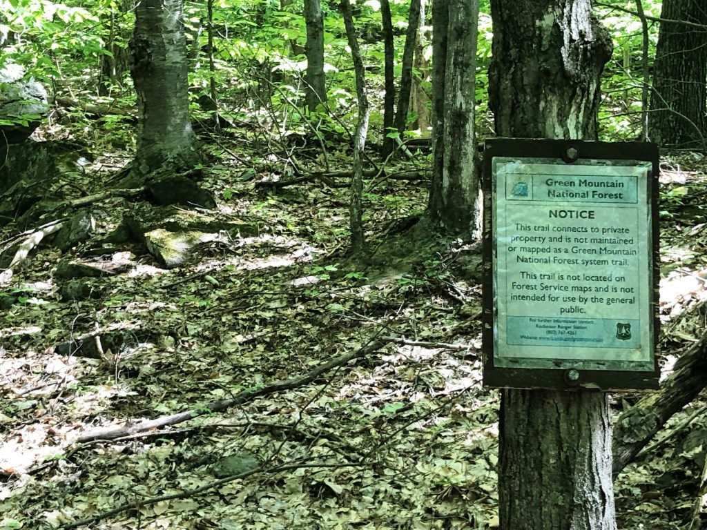
I started off at one of my favorite trailheads, the Falls of Lana parking lot just south of Branbury State Park, and ran up to the point, at about a half mile, where the trail makes a sharp hairpin turn to the right to ascend to Silver Lake. Instead, I went straight, as if I was ascending the Rattlesnake Cliffs, and shortly afterwards took the branch to my left on the Aunt Jennie Trail. I had vague memories of a small sign pointing to a weak, left turning trail at some point on the ascent, which brought me pretty easily to the cave. Sure enough, about a mile into my run, I saw a weak left-turning trail, but the sign, instead of pointing to “caves” as in my remembrance, there was only a sign making sure that people stayed on the well-maintained forest service trail. Nonetheless, I assumed that this was the trail that I was looking for. Wrong.
About 50 yards into this trail, I began to question whether I was on a legitimate trail, or some sort of herd path, but as I ran around a corner, I found a forest service sign reminding me that I was on a privately maintained trail (Camp Keeywaydin‘s presumably), not one of their trails, and that, combined with relatively recently painted white blazes on occasional trees told me that I was on what had been, at least at one time, a trail.
Pretty soon along this trail, the terrain got very rugged. It felt very reminiscent of the herd paths I experienced in the Adirondacks while working towards my 46’er membership 20+ years ago. It was narrow, rocky, obscured by leaves, and seemed to pay no attention whatsoever to any sense of contemporary trail design and maintenance. In other words, it made for wonderful adventurous exploring, but terrible running. To put the next two miles in perspective: I typically run 9-10 minute miles on most trails, maybe slowing down to 15 minute miles on challenging terrain. A typical hiking pace on maintained mountain trails is 2.5-3 miles per hour. It took me 80 minutes to cover the next two miles.
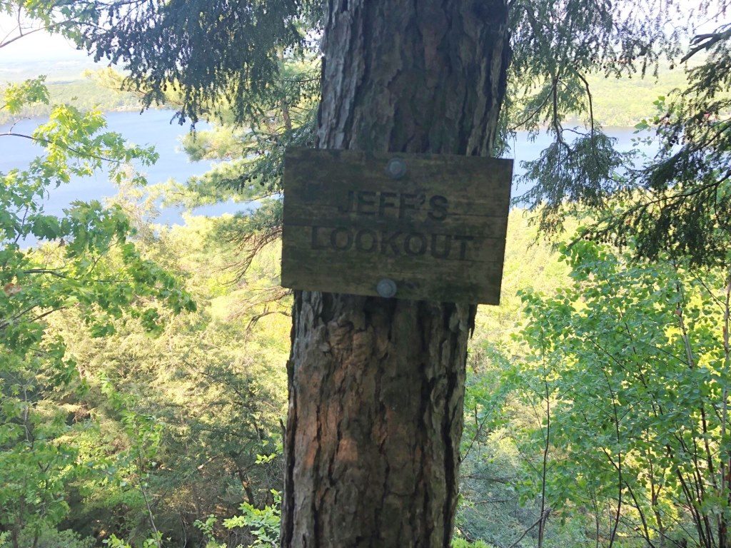
It took some basic routefinding skills to find my way through this section. It is very important to be constantly making note of your surroundings on terrain like this, so that in the frequent cases when backtracking was required, I found myself back to where I was last confident I was on the trail. Fortunately, there were enough white blazes so that in the very frequent sections where the trail disappeared, or was obscured by fallen trees, that I could always look around for a blaze. If I didn’t see one, I backtracked. Did I say I did a lot of this? Being constantly on the lookout at the terrain made it difficult to even run slowly, as the uneven terrain made it important to watch my feet, in turn missing blazes! I also realized that I was not on the trail of my memories, as I didn’t remember it being this rough, and there was no sign of “Speedy’s Cave”. I wasn’t worried about getting lost – the topography was simple enough, and I knew that buswhacking uphill would take me to the summit of Moosalamoo, although the little section called “the Rattlesnake Cliffs” might make that challenging, and I knew that there were cliff bands below me, albeit not as extensive. But, the fact that there were blazes told me that I had to be going somewhere. That said, I was about ready to turn around, when I received a sign from the gods that this was where I was meant to be: A sign on a lookout, with a lovely view of Lake Dunmore. What did the sign say? Jeff’s Lookout! So, of course I had to keep going. Curiously, on the next tree there was a much older sign, with the word “lookout” still legible, but with an otherwise unreadable name, but not Jeff, above it. Apparently Jeff usurped this cliff from someone else at some point in the past!
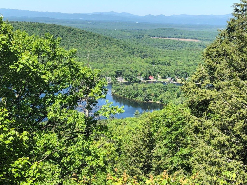
From this point, the trail zigzagged up and down the side of the hill, for reasons that were not at all apparent from the terrain. This grousing aside, this was a very pretty section, with several more overlooks, some named with signs, some not. But running was very much out of the question. The least obscured overlook bore no name that I could discern, but it shows just how pretty the views of the lake could be.
A little further on, I finally found the first true trail marker – a sign saying that the trail I was joining was called “The Wildcat Trail”, which seemed to follow the hillside, continuing north, and another arrow pointing straight up the mountainside, indicating that it was the most direct way to the Rattlesnake Cliffs. Years ago, I had noticed a discretely marked and precipitous trail descending from the cliffs, and decided against ascending them this way, at this time. Not long after this, I saw a sign pointing up the hill……called..(drum roll please) THE CAVE TRAIL!
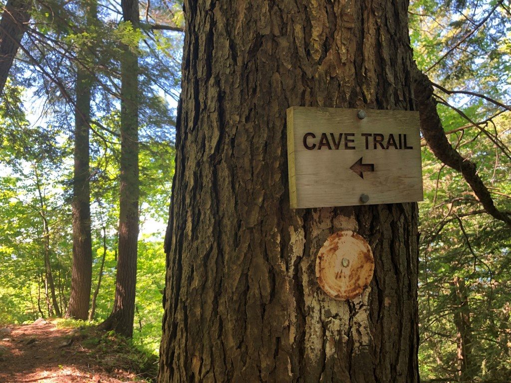
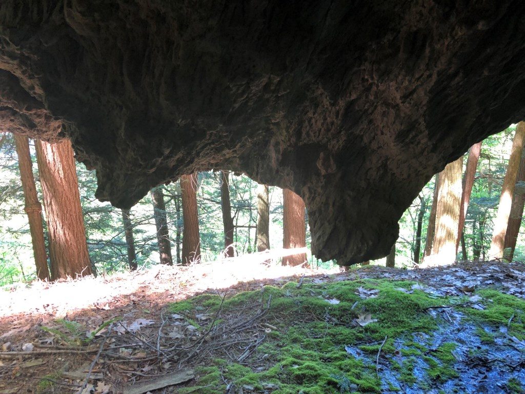
The ascent at this point was very scrambly, and I may well have been the first person to ascend it this year. But, after not too long, I found myself at a small cave called “Curly’s Cave” and standing inside it, looking out, I felt like I was in the mouth of a monster, looking past the teeth. I can imagine that this must be a favorite for Keeywaydin and Songadeewin campers.
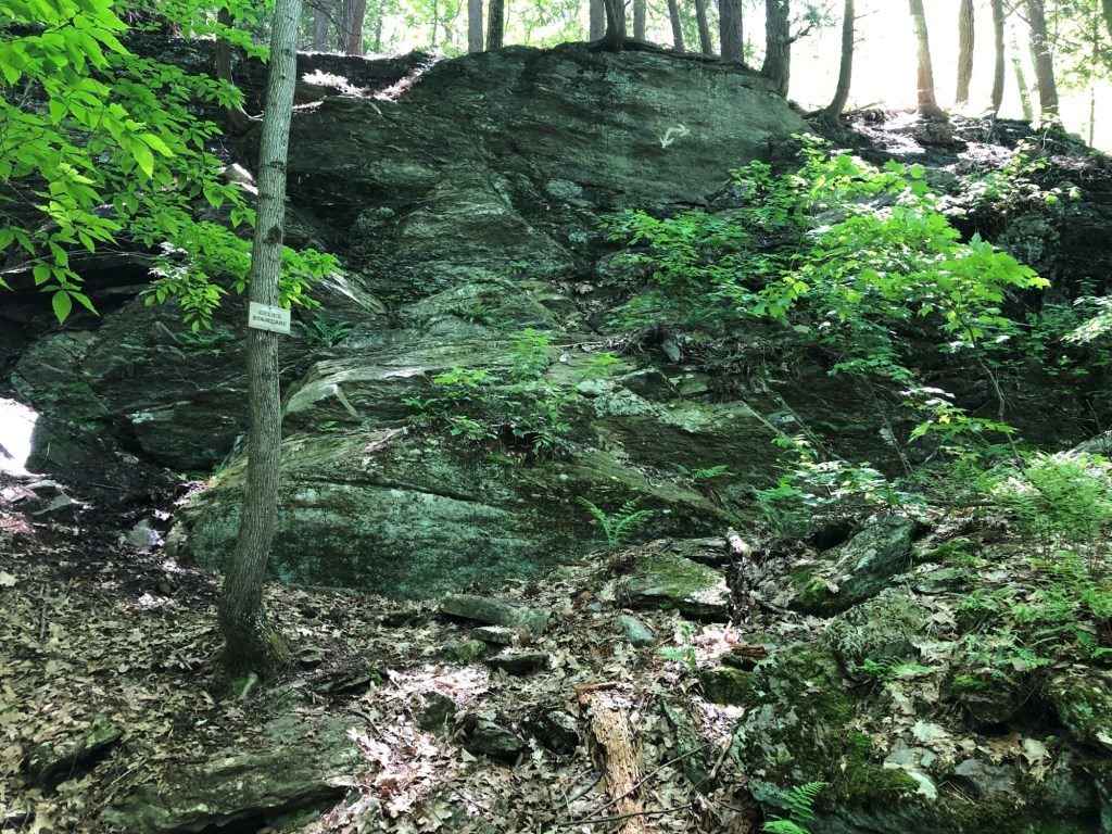
After the cave, I kept going up the steep incline, hoping that the trail might veer to the south, perhaps even connecting with the now distant Speedy’s cave, but the trail instead took a turn to the south, so I decided to backtrack to the start of the Cave Trail, and continue on the increasingly strong trail heading towards the camp. One last adventurous section was where the trail descended a cliff band known as the “Deer Staircase”.
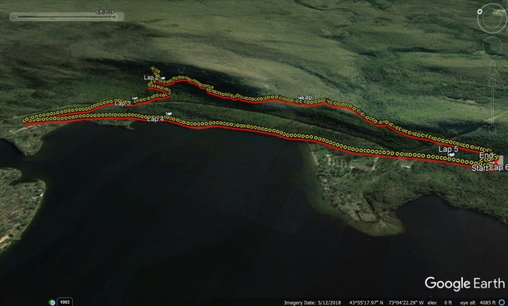
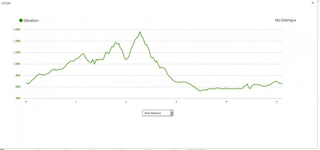
This trail eventually joined a well worn, double track trail called “Steve’s Trail” where I arbitrarily chose to go left, finally running full stride for the first time in well over an hour, eventually joining “The Summit Road” – a dirt road, finally joining Rt 53 across the road from Camp Keeywaydin. All that was left now was a mile and a half of roadside running, dodging cars, to return to my vehicle. This was quite possibly the slowest 5 miles I have ever done in Vermont – the first mile, and the last two miles were real running, but one two mile section in the middle was some of the roughest terrain I have been on for a long time. Check out the altitude profile! All the ups and downs on this run/hike/scramble added up to about 1500 feet of climbing and descent, and this relatively short distance ended up taking me almost 2 hours. In other words, it was a fun little local adventure. I look forward to trying to find Speedy’s Cave later this summer, and if successful, I will post it to this blog.
Finally, I have been led to believe that the trails of Camp Keeywaydin are open to the public, but I would guess that they would rather we not use them, at least close in to the camp, while camp is in session. I will check in with a friend on their permanent staff to clarify this, and will make an addendum to this post when I know for sure.
You do find some interesting places. I would like to be involved with the next cave adventure.