Our bodies stirred as the sun squeezed through the blue tent flaps. The valley below 12,000-foot Mount Wahoo lit up as the sun rose over the summit. Birds sipped on the cool water in Little Basin Lake, and my father, my younger brother and I emerged from our tent.
Having completed many trips in the California Sierra backcountry at lower elevations, we decided to take a new approach to backpacking and explore somewhere off trail with this trip in early August, 2013. My father had researched trips relatively close to our home in San Francisco that would still prove challenging. After reading numerous books about the Sierra mountain range in eastern California, we settled on a five-day portion of the 195-mile Sierra High Route trail. The particular section we chose, known as “Whitebark Country,” begins on well-maintained trails, before heading off trail, above the timberline, and up into high-elevation “Lake Country.”
In two weeks I would leave for college, and my brother Reed would head off to boarding school shortly after. We had tried to convince my older brother, my mother, and my younger sister to join, but various commitments meant we departed for the mountains alone. With one more chance to spend time together before parting ways, we took a risk with a more difficult itinerary, and left for the mountains.
To start the trip, we hiked up and over Bishop Pass in the Northeast section of Inyo National Forest, down into LeConte Canyon, and to the base of Muir Pass. From there we turned off trail, hoping to see parts of these mountains that only a few people witness every year. The Sierra High Route is known as a demanding trail, which almost no one completes in one attempt. The trail runs parallel to the John Muir Trail, staying farther east and at a higher elevation. It is full of class-3 rock faces, meaning footholds and handholds are unstable, and must be carefully picked. Without a blazed trail leading the hiker, anyone who walks the route needs a detailed map and compass. Making sure we prepared as thoroughly as possible, we followed the imprecise trail.
On the third morning, we moved slowly, and hobbled to the water source to start the slow process of cooking a meal above 10,000 feet. The toll of the past two days showed; oozing blisters and aching muscles needed treatment before the hardest day yet began. I pulled out the powdered eggs which, when mixed with hot water, would serve as our first meal of the day. We stuffed our remaining gear into the large packs. Three bear canisters, a three-person tent, clothing, a medical kit, sleeping bags and pads had to squeeze into three 65-liter backpacks. Boiling water meant one thing; the food for the morning was almost ready.
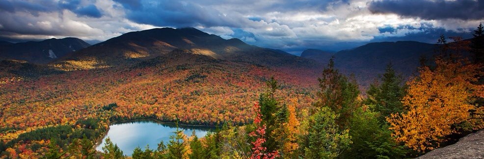
That day’s journey on the Sierra High Route appeared simple enough on paper: hike west down Little Basin, turn north and circle the base of Wahoo, head up and over Snow Tongue Pass, and finish down in Piute Basin. We found out soon enough, however, that our task required much more work than we anticipated. Starting down the basin, the rocks and trees thinned to reveal, thousands of feet below, the entirety of Evolution Basin, lined with lakes and foliage. High Sierra peaks toward the south and southwest completed the picture, and a bright blue, cloudless sky topped it off. We saw below in the valley, where hikers of the Pacific Crest Trail and the John Muir Trail meandered through the much easier terrain than what greeted us several hundred feet higher. But when planning the trip, we intentionally chose not to tread on these well-worn paths.
As we rounded the final bend high above the basin, the top of Snow Tongue Pass emerged, tucked between a knife-like peak to its right, and the dome-topped Mount Wahoo on its eastside. Seemingly endless talus led up to the saddle. Realizing we had a heavy amount of work ahead, we began to climb. At first, small boulders here and there were easily avoidable. A creek bed provided cold water to drink when we desired, and soft grass to walk up, consoling our already tired feet. The rocks grew in numbers and size slowly but steadily, and before we reached the halfway point of the climb, the pebbles disappeared and truck-sized behemoths provided a precarious walkway. We had to preplan every step; a misguided foot plant onto an unbalanced rock could lead to an eight-foot fall into a crevice between the stones. Slowly, we made our way up, sometimes shaking off our bias toward foot travel to use our hands to haul our bodies and packs up. New leather boots dug equally into mineral and flesh, cutting hands and scraping knees.
Now only a hundred vertical yards from the top, we took a much-needed rest to regain our breath, and enjoy the view. In the distance, 13,000-foot peaks Mt. Darwin and Mt. Goethe stood as humble reminders that our particular climb paled in comparison to treks up these mountains. I dipped my hands into the cold creek, and washed fresh stream water down my face, cooling it instantly. Relinquishing our comfortable positions, we started again; we knew many miles lay ahead of us, and the day was only getting hotter. Another thirty minutes of physical exertion, and we reached the top.
From the pinnacle of Snow Tongue pass, typical High Sierra terrain unfolded in every direction. To the west, jagged rocky peaks towered above deep blue lakes. Thunderclouds hovered around the spires, threatening to ruin any plans of travel in the backcountry. Looking east, the vista was harsher. A near vertical drop greeted any High Sierra hiker daring enough to try. Stable boulders became loose scree, which in turn changed to sand, and a slippery snowfield. After coming to the conclusion that this was in fact the trail, we braced ourselves for a long, nervy down-climb.
Descending by age, we began our slide down. My father went first, outlining the path my younger brother and I would follow shortly. After all, he had planned this “goodbye” trip, and although we knew it would be challenging, he wanted to make sure it was as unproblematic for us as possible. The rocks acted as hand-holds, as the footing appeared too unpredictable to rely on. Slowly, we improvised switchbacks in the mountain, to avoid any chance of falling down the slope. Footing readjustments here and there caused nervous glances and reassurances that everything was under control. Rocks flew down unannounced ahead of each of us, mandating precaution. We descended in shifts. My father made his way a few yards down, then cleared the area so I could begin. Once I reached him, my younger brother started, knowing my father and I rested safely out of harm’s way. After two hours of hesitant ambling, we finally reached the bottom, where Wahoo Lake greeted us.
Once we arrived at Wahoo Basin, glances up toward Snow Tongue Pass raised skepticism; had we really just come down that rock face? There was no obvious path on the hillside. Boulders and gravel hid any possible combination of footholds, and the grade of the mountain appeared too steep. However, yes, we really had just come up, over, and down the pass. Marveling, we relaxed in a comfortable location next to the warm lake. With the hardest day of the trip behind us, and two relatively easy days ahead, relief enveloped our group.
A quick dip into the cold Wahoo Lake explained the origin of its name. Then, pots and pans emerged again, and we began the tedious process of heating up water for dinner. The day’s hike took a lot out of our bodies. Even with our immense fatigue, we all smiled and laughed. We knew this would be the last time we would be together for a long time, so our emotions overtook our exhaustion. Once again, a powdered delicacy was the prize for completing a physical task. As the sun faded behind Snow Tongue pass, the blue tent flaps zipped up, and we tucked our tired bodies back into the welcome warmth of our sleeping bags.
“The Imprecise Trail” by Kirk Horton
Leave a reply