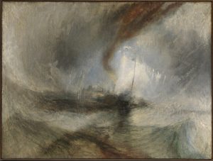
Dodo Jin Ming, Free Element, Plate XXXI, 2002

Dodo Jin Ming (1955 – ), Free Element, Plate XXXI, 2002, gelatin silver print. Middlebury College Museum of Art. Purchase with funds provided by the Christian A. Johnson Memorial Art Acquisition Fund, 2005.035.

Legend has it that the famous nineteenth-century British painter, Joseph Mallord William Turner, envisioned his painting Snow Storm – Steam-Boat off a Harbor’s Mouth while roped to the mast of a ship for four hours during an actual storm at sea. Whether or not this actually happened, Turner must have looked carefully at the ocean to create his vortex of water, waves, and sky.

Joseph Mallord William Turner, Snow Storm – Steam-Boat off a Harbor’s Mouth, exhibited 1842. By permission of Tate, London, accepted by the nation as part of the Turner Bequest, 1858

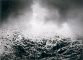
Photographer Dodo Jin Ming has followed in Turner’s footsteps, producing mesmerizing views of storm-roiled waters and turbulent clouds. Working in the midst of intense weather conditions at sea, she places herself at great personal risk to interpret the sublime power of nature.

Born in Beijing, Jin Ming had a successful career as a violinist before taking up photography in 1988. Profoundly influenced by the work of Joseph Beuys, Jin Ming considers herself a conceptual artist who works in photography. In the Free Element series, she produced her prints from two negatives, one for the sea and the other for the sky, utilizing the nineteenth-century combination printing technique invented to get around the limitations of early technology. Unlike earlier photographers, however, Jin Ming’s use of combination printing is not in the service of verisimilitude; rather, it serves to heighten the emotional effect of a first-hand confrontation with massive waves and stormy skies.

Brett Weston, Sandbar, Glen Canyon, Utah, 1960

14453
Brett Weston (1911-1993), Sandbar, Glen Canyon, Utah, 1960, gelatin  silver print. Middlebury College Museum of Art. Gift from the Christian Keesee Collection, 2016.049.

screen-shot-2016-12-16-at-7-50-56-amBrett Weston first visited Glen Canyon in 1959, at that time the site of a proposed dam for water storage and hydroelectric power. Unlike Eliot Porter, whose photographs of the canyon became an important vehicle for the Sierra Club, Weston’s photographs did not play a role in the environmental debate that surrounded the dam project. Rather, they were quiet studies of trees, light, and water that fit Weston’s larger project of finding beauty by looking closely at often overlooked details of the natural world.

In this photograph, Weston emphasizes the shimmer of light on the surface of the water, offset by the subtle pattern of sand along the edge. The sharp contrast between highlights and shadows adds drama to the simple subject. As Weston put it in 1982, “It’s what one’s eye sees and isolates. It’s that simple for me. I’m looking for form and design. My theory is that it’s in my genes.”[footnote]Peter Nabokov, “Natural Form: Photographs by Brett Weston,” Camera Arts 2(November 1982), p. 95.[/footnote]

Emmet Gowin, Old Hanford City Site and the Columbia River, Hanford Nuclear Reservation, near Richland, Washington, 1986

Emmet Gowin (1941 – ), Old Hanford City Site and the Columbia River, Hanford Nuclear Reservation, near Richland, Washington, 1986, toned gelatin silver print. Hood Museum of Art, Dartmouth College, Hanover, New Hampshire. Purchased through a gift by exchange from Mr. and Mrs. Joseph H. Hazen, 20015.17.9. © Emmet Gowin; courtesy Pace/MacGill Gallery, New York.

screen-shot-2016-12-16-at-7-50-56-amIn 1986, while in the sixth year of photographing the aftermath of the Mount St. Helen’s volcanic eruption in the state of Washington, Emmet Gowin made a side trip to photograph the nearby Hanford Nuclear Reservation. Recently described as “the biggest, most toxic waste site in the Western hemisphere,” the Hanford facilities were created in 1943 to produce plutonium for the Manhattan Project.[footnote]Ken Boddle, “6 reasons to know about Hanford’s nuclear waste,” http://koin.com/2014/04/24/6-things-know-hanfords-nuclear-waste//. Accessed Dec. 12, 2016.[/footnote] In operation from World War II through the Cold War, nine nuclear reactors were built along the Columbia River where approximately 475 billion gallons of contaminated water were released into the soil. Although efforts to clean up 56 million gallons of radioactive waste have been underway since the 1980s, underground storage tanks are leaking into the soil with the potential for serious environmental consequences.

In Gowin’s aerial photograph, Old Hanford City Site and the Columbia River, Hanford Nuclear Reservation, near Richland, Washington, the staggering scale of the environmental abuse at Hanford is not immediately apparent. A radiant river winds through a stark landscape to a hazy horizon in what appears to be a continuation of the nineteenth-century tradition visualizing ethereal moments in majestic nature. However, upon knowing the more about the location and its place in twentieth-century environmental history, that glowing river winding through a radioactive landscape becomes ominously menacing.

Although Gowin first achieved prominence on the basis of his portrait and figural work, his photographs of Mount St. Helen’s, the Hanford nuclear reservation, as well as aerial photographs of the effects of nuclear testing at the Nevada Test Site have given Gowin an important place among photographers who record places scarred by human or natural devastation. As poet Terry Tempest Williams has observed, “Emmet Gowin has captured on film the state of our creation and conversely, the beauty of our losses.”[footnote]Terry Tempest Williams, Emmet Gowin: Changing the Earth (New Haven: Yale University Press, 2002), p. 131.[/footnote]

John Pfahl, Trojan Nuclear Plant, Columbia River, Oregon, October 1982/printed 2014. Pigment Print on Platine Paper. Middlebury College Museum of Art, purchase with funds provided by the Fine Arts Acquisition Fund, 2015.018

After dismantlement, the nuclear reactor from the Trojan Nuclear Plant, photographed in 1982 by John Pfahl, was enclosed in concrete foam, sheathed in blue shrink-wrapped plastic, and taken by barge to the Hanford Nuclear Reservation where it was buried in a forty-five-foot deep pit and covered with gravel.

Richard Misrach, Hazardous Waste Containment Site, Dow Chemical Corp, 1998

Richard Misrach’s photograph of a hazardous waste containment site on the Mississippi River is included in his book, Petrochemical America, published in 2012 together with landscape architect Kate Orff’s ecological atlas of maps and drawings of an area known as “Cancer Alley.”

Listen as Middlebury College student Danielle Weindling describes the project, and scroll down for Middlebury student Scott Waller’s musical interpretation.

Richard Misrach (1949 – ), Hazardous Waste Containment Site, Dow Chemical Corp, 1998, 1998/2001, chromogenic print. Middlebury College Museum of Art. Purchase with funds provided by the Contemporary Photography, Film, and Video Acquisition Fund, 2004.026.


David Maisel, The Lake Project 19, 2002

David Maisel (1961 – ), The Lake Project 19, 2002, archival pigment print. Middlebury College Museum of Art. Purchase with funds provided by the Fine Arts Acquisition Fund, 2016.082.

David Maisel’s The Lake Project is a series of aerial photographs of the remains of eastern California’s Owens Lake, which was drained in the early twentieth century to provide water for the city of Los Angeles.


Watch and listen as guest curator Kirsten Hoving and photographer David Maisel share their thoughts about the project:


Joel Meyerowitz, Bay Sky Storm, 1987

Joel Meyerowitz (1938 – ), Bay Sky Storm, 1987, chromogenic contact print. Middlebury College Museum of Art. Gift of Dr. and Mrs. Stephen Nichols, 2014.118.

One of the most highly regarded color photographers of the second half of the twentieth century, Joel Meyerowitz published his first book of photographs, Cape Light, in 1978. His glowing images of the coast and towns of Cape Cod struck a popular chord, and the book went on to sell 150,000 copies. A follow-up project, the Bay/Sky series, was produced in the 1980s near Meyerowitz’s summer home in Provincetown. Like the images in Cape Light, the Bay/Sky series was shot with a large format Deardorff camera that resulted in detailed, meditative images.

Working with an 8 x 10 view camera, Meyerowitz moved away from the street photography he had practiced previously and experimented with longer exposures that conveyed a sense of luminous stillness. Bay Sky Storm captures a transitional time between clear and stormy sky—an ominous time reflected by the boat that moves to shore and the patterns of the waves on the sand. Norman Mailer wrote of such photographs in the introduction to Meyerowitz’s book, Bay/Sky, “So he treads with the lightest touch and the most exquisite sense of the moment into which those turns of the atmosphere that inform us of the wayward and not always unsinister whims that breathe in colloquies between cloud and sky, as if it is in the flux itself, and nowhere else, that we can find our few absolute statements of existence.”[footnote]Norman Mailer, “Foreward,” in Bay/Sky (Boston: Bulfinch Press, Little, Brown and Company, 1993), n.p.[/footnote]

Meyerowitz would go on to photograph a different kind of storm: the destruction of the World Trade Center in his book Aftermath, published in 2006. The only photographer given access to the site in 2001, Meyerowitz produced a record of the efforts and bravery of the workers who assisted in the clean-up process.

James Balog, Greenland Ice Sheet, 28 June 2009, Adam LeWinter surveys Birthday Canyon, 2009

James Balog (1952 – ), Greenland Ice Sheet, 28 June 2009, Adam LeWinter surveys Birthday Canyon, 2009, chromogenic color print. Middlebury College Museum of Art. Purchase with funds provided by the Fine Arts Acquisition Fund, 2015.006.


James Balog photographs vanishing glaciers around the world.  Learn more with this video, then scroll below to hear a musical interpretation of Balog’s work, composed and performed by Sam Kudman, Middlebury College Class of 2017.


Jeff Rich, Blue Ridge Paper Mill, Pigeon River, Canton, North Carolina, 2008

jeff-richblue-ridge-paper-mill
Jeff Rich (1977 – ), Blue Ridge Paper Mill, Pigeon River, Canton, North Carolina, 2008, archival pigment print. Middlebury College Museum of Art. Purchase with funds provided by the Fine Arts Acquisition Fund, 2015.230.

Jeff Rich’s photographic project and accompanying book, Watershed: The French Broad River, published in 2012, chronicles the complexity of a river’s environmental and social ecology. This photograph of the Blue Ridge Paper Mill, the cover image of the book, has been called “a beautiful study of the effects of pollution.”[footnote]Daniel Coburn, “Watershed,” Fraction Magazine, Issue 38. http://www.fractionmagazine.com/review/watershed. Accessed Nov. 30, 2016.[/footnote] Nestled in a green valley and situated on the bank of the river, the factory glows under the golden rays of the morning sun.

This is a disturbing image. The clouds emitted by the factory are beautiful, but troubling, given the rise and fall of the environmental fate of the long-polluted Pigeon River. The paper mill has polluted the river for over a century, and its water is not drinkable for downstream communities. Toxic releases to the water are over 100,000 pounds a year.[footnote]“The long struggle for a clean Pigeon River,” 2016. http://cwfnc.org/polluter-accountability/pigeon-river/ Accessed Nov. 30, 2016.[/footnote]For a brief period the river was shaping up to be a success story, as clean-up efforts went forward in the late 1990s. However, regulatory neglect seems to have reversed the brief progress made, and the river is becoming increasingly vulnerable.

But this photograph is less about the river and more about the sky, as the clouds of steam and smoke are discharged from coal-powered boilers into the atmosphere. According to the Organization for Economic Co-operation and Development, the paper industry is the third largest producer of greenhouse gases.[footnote]Henry J. Fair, The Day after Tomorrow: Images of Our Earth in Crisis (Brooklyn, NY: PowerHouse Books, 2010), p. 44.[/footnote] The mill is reputed to be the largest industrial air polluter in the western part of the state, according to federal emissions reporting. In 2015 the state of North Carolina pledged $12 million toward upgrades of some coal boilers and conversion of others to natural gas, with the goal of reducing air pollution; however, given our current political climate and the reversal of environmental gains, the fate of the river is uncertain.[footnote]“The long struggle for a clean Pigeon River,” 2016. http://cwfnc.org/polluter-accountability/pigeon-river/ Accessed Nov. 30, 2016.[/footnote]

Listen to commentary from Kirsten Hoving and Jeff Rich :