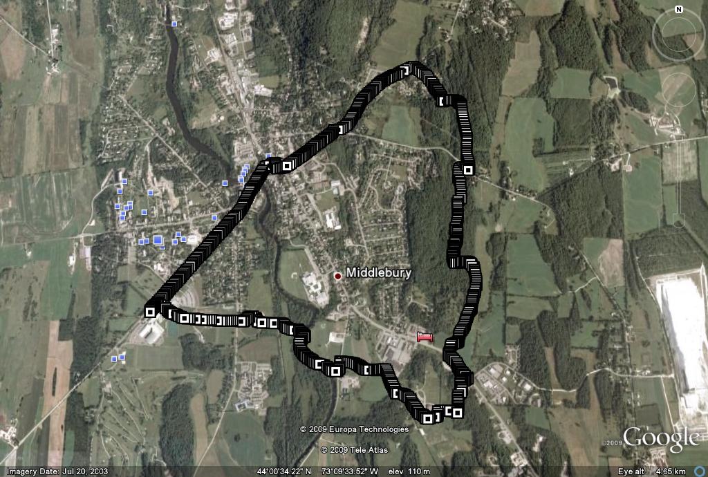
Probably just about every trailrunner in Middlebury knows and enjoys the Trail Around Middlebury, or “TAM”. It circumnavigates the village of MIddlebury, going through a mix of fields and forests, doing a remarkably good job of avoiding populated areas. I am told its complete circumference is about 16 miles, making for a very long trail run, but most of us will want to break it down into smaller segments. A map of the entire trail can be found at http://www.maltvt.org/_data/n_0001/resources/live/TAM-MAP2008.pdf. This is a great map, but can take a while to load, as it is over 20 MB!
This segment of the TAM goes through three of the named forests preserves in town, the Murdock Preserve, the Battell Woods, and the Means Woods. Starting at the college fieldhouse, head out the back door, across the track stadium, and cross over South St. Take the dirt road which heads behind the baseball diamond, cross the railroad tracks until you get to the suspension bridge over Otter Creek. You can add challenge to this run by getting a few of your friends to run the bridge with you, with your steps out of sync. Try it and you will see what I mean! Take a sharp right at the bridge, staying on the trail between the creek and the fence. Circle around the ballfield until you get to Creek Rd., where you take a left, and a right back into the field a few seconds later. The next field used to be an empty meadow, but now the trail weaves between some of the homes which have recently been built here. Take a right turn on Middle Rd., which you follow until you get to the Middlebury Union Middle School. Run behind the building until you get to the crushed stone path heading into the Murdock Woods in the back. There are several trails you can take here, making the run longer or shorter, but I usually take the shortest version, following the signs that lead you to Rt. 7. When you reach Rt. 7 at around 2 miles, take a left turn and look for an opening to get across the road without becoming road kill.
Reenter the meadow across the road, where the trail runs along the edge of the Batelle Woods. The aroma of the adjacent field is great after it is freshly mowed, but not so nice if the manure spreader is at work. After about a quarter mile along the meadow, the trail makes a well marked left turn into the woods. The Batelle woods are crisscrossed with numerous trails, but the course of the TAM is generally well marked and the obvious major trail, although other paths are worth checking out when you get the chance. When you get to Quarry Rd., head right for about 50 yards, cross over, and enter the Means Woods at the gate. The TAM follows and old dirt road for about a half mile before it takes a left turn downhill on a well-marked path, eventually joining Washington St. Extension, where the rest of the loop is on village roads. Go left on Washington St. Extension, and follow it back to Main St, which will eventually take you back to the fieldhouse.
The measured length of this route is 5.6 miles, but it can be easily stretched out over 6 with a few different twists and turns on the trails.

Thanks for the detailed description of the Trail Around Middlebury! I thought you all might be interested in a fun event with prizes and freebies that is taking place at 10 am on Sunday, Sept. 27th, which is the TAM Trek, the major fundraiser for TAM trail maintenance. Even though trail maintenance is carried out primarily by volunteers, there are expenses for materials, mowing, and supplies. More information, including a registration brochure and pledge form, is available at http://www.maltvt.org by clicking on the TAM trail button.–Katherine, Middlebury Area Land Trust volunteer
This is indeed a great event – I participated in it last year,and encourage others who love the TAM to do so as well.
There is a new link to the TAM map! The new link is now http://www.maltvt.org/TAM-MAP2008.pdf.
Thanks!