On July 22, 2012, my right lung collapsed. It was four days before I was due to return home from my semester abroad in Costa Rica. I was sitting on my host family’s couch, laughing at a comedy on the television. I stopped laughing when a sudden violent pain and tension gripped my right chest. As my breathing hitched, I felt like a ship slowly listing to the side, about to swamp. What was happening to me? Was I having a heart attack? Five days, a few shoddy medical procedures, and a lot of battling with insurance companies later, I was on a medical evacuation Learjet, a tube poking between my ribs to drain the air that had accumulated in my vacant, lung-less chest cavity. Soaring above the stormy dustbowl states was the only time I’ve ever seen lightning from above. We touched down in my hometown, Billings, Montana, and after a surgery and another seven days spent languishing in a hospital room, I was free to go.
That was the first time.
In August of 2013, almost exactly one year later, my left lung dropped while I was changing costumes for a musical I was part of. This time around, the tube perversely felt like it belonged in my chest, like a dagger in a sheath.
Less than two months later, I struggled up the brutal pitch of Mount Algonquin, unsure of how I’d been coerced into coming along. Algonquin is the second highest peak in the Adirondacks, a New York State mountain range covering an area the size of Vermont, with an elevation of 5,114 feet. I thought this would be child’s play compared to the highest peak in Montana, Granite Peak, at 12,807 feet.
I leaned against a boulder, panting, the straps of my pack digging into my shoulders and hips. The path had disappeared miles ago when it intersected with this creek. The only sign that my group was still on a trail was the periodic flash of yellow from the small round trail-markers pinned to trees every seventy five feet or so along the steep streambed. When Andrew, Joe, Azelie, Lydia, and I trekked our first miles into the Western High Peaks Wilderness the day before, I had been impressed with the amount of maintenance that seemed to have been lavished on the trails by volunteer workers; flattened logs bridged muddy sections of trail and well maintained plank bridges crossed each ditch. In Montana, most trails are simple dirt tracks. So for me, this had been a welcome surprise.
At least until now. It appeared that halfway up Mt. Algonquin, the trail-breakers had gotten lazy and decided that the easiest way to reach a summit was by walking straight up. Thus, they abandoned the concept of a trail and dumped hikers into this wet stone chute for the remainder of the climb.
Above the boulder where I rested, the streambed rose in steep slabs and terraces, resulting in a jumbled landscape of waterfalls and eddies, small trickles and gushing streams. There was a definite path of least resistance up the falls, a vague staircase of boulders and logs that would take me over each small waterfall and onto the next slab of rock.
Picking their way around the pools and drops above me were three of our group—shirtless, mountain-man, gung-ho, Idaho Joe; relaxed and loquacious Andrew; and cheerful, all-too-happy-to-be-hiking-straight-up-a-goddam-waterfall, California girl Azelie.
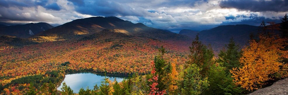
As they walked, they gushed about the beauty of the day. I couldn’t argue. The hike may have been grueling, but the temperature was perfect—just warm enough that I was content in a t-shirt as long as I kept moving. Behind me, the majesty of the High Peaks spread to the horizon between breaks in the trees, the crumbling towers and sagging valleys reminding me of a child’s sandcastle abandoned and battered by the surf. Patchy sheets of cloud and mist patterned the landscape. The distant town of Lake Placid intermittently gleamed and dulled as the sunlight came and went. Every now and then, a flurry of snow dusted the rocks before fading as if the flakes had blown out of my imagination.
Behind me, our final member, Lydia, labored up the rocks, her breathing even heavier and raspier than mine. Just a couple of days before, she had donated two pints of blood, effectively hamstringing her endurance. Nonetheless, she hiked doggedly upward. As she drew closer, I heaved myself upright and forced myself to climb. If the girl absent two pints of blood wasn’t slowing the group down, I wouldn’t either.
I only knew one of these people before yesterday: my roommate Andrew. One day the week before he had burst into our room, afire with excitement, as he usually is.
“Dude! Let’s go backpacking this weekend,” he said as he entered the room, slinging his schoolbag onto his bed. He engaged his whole head when he talked, bobbing it emphatically to punctuate his sentences. “I know a couple of great kids who are totally down. It’ll be great. We’ll get off campus, you’ll get to the see the Daks.” Andrew is from Pennsylvania, and the Adirondacks, or “Daks” as he likes to call them, are a childhood playground of his that he’d wanted to share with me ever since we moved in together at the beginning of the school year.
That sounded good to me. It was a couple of weeks into October, the middle of my first semester at Middlebury College, in Vermont, and we had a four-day weekend coming up. College was harder than I had expected. I was stressed out. Backpacking could be relaxing. I hadn’t had a chance to escape to the mountains since arriving on the east coast.
I agreed. It sure beat sitting around doing schoolwork.
On Saturday morning, Andrew and I rendezvoused with Joe, Azelie, and Lydia and loaded our towering packs into Joe’s car. I crawled into the cramped backseat and Joe hit the gas. Joe’s driving set the mood, all acceleration and roller-coaster like turns. We zoomed west out of Middlebury on the 125, Lake Placid bound.
As we drove, we discussed the places we were going to stop on the way back from our two nights in the wilderness. A small gas station that sells maple ice cream. An outdoors store in Lake Placid that Andrew said was “super legit.” A burger joint.
The hour and a half long drive evaporated like gasoline. The excitement in the air felt flammable as Joe turned the car onto a dirt road a few miles past Lake Placid, New York. The road was lined with the parked cars of other hikers and campers. We had to drive several hundred feet to find a spot to park.
As quickly as possible, we distributed food, bear barrels, and other communal supplies. We were all itching to get on the trail. Finally, we hoisted our packs, heavier now than they had been minutes before, and set off back to the main road.
We hiked along this road for three quarters of a mile, crossing a bridge under construction and climbing a mellow hill. Despite the clouds, the mood was bright and the conversation was as jaunty as our steps. Even in our heavy boots, none of us scuffed our feet as we walked.
Within fifteen minutes, the pavement transformed from a road to series of parking lots. The trees thinned as the forest gave way to large, triangular Heart Lake. A couple of families camped in blue, dome-shaped tents on the grassy beach, and a few boats colored the steel-gray water of the lake. Tree covered slopes lined the far shores, but clouds obscured much of my view. To the right, a wooden, cabin-like lodge sat a short distance from the campers. This would be the Adirondack Loj, our last chance for tap water. I dropped my pack on a long bench outside and passed into the building.
Adirondack Loj was built in 1927 after the original structure burned down in a wildfire. Today it’s a boarding house for hikers, owned and operated by the Adirondack Mountain Club. According to the lady behind the counter in the spacious entry room, previous owner (and inventor of the Dewey Decimal System used to organize libraries) Melvil Dewey, an advocate of spelling reform, decided on the strange spelling of “lodge.”
After filling up our bottles, we located the trailhead at the back of the parking lot behind the Loj and signed ourselves in before beginning our trek south into the woods. Our destination for the night was Marcy Dam, an old structure surrounded by campsites and lean-tos. It was only mid-afternoon, so we weren’t worried about making the two-mile hike within any particular timeframe. Nevertheless, we moved at a steady clip, the easy, rolling trail quickly passing beneath our feet.
At this point in the fall, the lack of foliage afforded me an easy view of my surroundings through a latticework of naked, bone-white birches and green pines. I watched as green, brown, and gray mountains rose up on either side of me, their peaks sharp against the clouds.
We arrived at the dam, a wooden structure that held back the waters of shallow Marcy Brook, creating a small reservoir and a waterfall. We set about searching for a lean-to, but found that every one in the surrounding hills was occupied.
The only thing to do, we decided as we hunched around a map spread on the wooden decking of the dam, would be to hike the three miles southwest to Lake Colden and see if we could find a campsite there.
So our hike became a much longer, much more rugged walk than we had planned.
The peaks grew higher and the cliffs on either side drew closer as we walked. After a couple of miles, we reached Avalanche Lake, a narrow, half-mile long strip of water squeezed from either side by the imposing rock walls of Avalanche Peak and Mt. Colden. We took a brief snack break on a soggy beach before returning to the trail, a thin strip of tumbled rocks and soil that occupied the space between the western wall and the water.
The hiking here involved more climbing and hopping than actual walking. It was tiring, but fun to bound over the tops of boulders. In places, the shore strip disappeared entirely and we were left to walk on a wooden boardwalk that protruded from the cliff. These walkways are called hitch-up Matildas. The Adirondack Mountain Club constructed them during its early days so that ladies walking through the mountains wouldn’t have to get their skirts wet in the lake. There were ample gaps in the boards through which I could see the dark, cold water of Avalanche Lake. I kept my eyes glued to my feet during these sections.
After Avalanche Lake, it was a short hop to Lake Colden. As far as I could tell, Lake Colden was a similar shape to Avalanche Lake, but about twice as long. The slopes that dominated the shorelines were more gradual, with fewer exposed rock faces. It was a simple matter to find an open lean-to nestled out of sight of the lake next to a shallow stream. We fell asleep that night with the sunset, abuzz with excitement for the climbing we would do the next day.
And that’s how I came to be halfway up Algonquin, struggling my way up a waterfall towards the promise of lunch.
“You know, I bet we could make it over Iroquois, Algonquin, and Wright today,” said Andrew from above me, his optimistic tone making the task sound almost reasonable. Andrew is intent on becoming a 46’er, or a hiker who has summited all 46 of the Adirondacks’ peaks over 4000 feet. Admittedly, this would not be a remarkable hike, but I wasn’t so sure about nabbing three in a day. As the crow flies, it was less than two miles from our campsite beside Lake Colden up the south face of Algonquin to the summit, but we’d been hiking for hours and the end was nowhere in sight. The going was steep, slow, and each glimpse through the trees to the distant ridge was demoralizing as it grew closer at an agonizingly slow pace. On top of that, we’d started our hike at about noon, allowing our bodies, more exhausted from the rigors of college than we had realized, to recharge a little bit.
The painful haze continued for another undefined period of time. With every labored breath, I imagined that I could feel the rows of staples that pinned the tops of my lungs to my chest wall. We moved out of the tumbling streambed onto an even steeper bare ramp of rock. Water covered the ground in a thin film and rushed silently past where I had already walked. I hardly noticed as the trees on my left and right gradually grew smaller and the temperature dropped. Time ceased to matter. I only thought about finding solid ground where I could place my feet.
The trees vanished from either side and I stopped walking. I turned a slow circle. I had broken through tree line!
Below me lay the High Peaks Wilderness, resplendent from this height, now visible as a chain instead of a broken line of peaks. Above me towered a barren escarpment of rock, piling up in terraced layers like soft serve ice cream on a cone. Square boulders and cairns added jaggedness to the smooth rock flows. Here and there tough yellow tundra grass clung to cracks in the rocks. This new world above tree line belonged to the ice and wind. The western side of each rock and blade of grass was coated in a white blaze of snow and ice, the wind stringing out the crystals laterally so that icicles formed sideways. Where the ground wasn’t wet, it was covered in a thin layer of ice, creating a dangerous checkerboard of slippery and safe all the way to the domed peak a half-mile away. The wind howled, threatening to push me down the mountain. Behind me, the border between frigid, ice covered wasteland and sheltered evergreen forest was almost perfectly delineated. The ice found refuge among the needles and cones of the first few rows of trees only, and the ice on the ground didn’t extend into the forest.
We assembled in a small rock alcove level with tree line and put on more layers to keep out the biting wind. Even Joe added a jacket and some gloves, although his legs stayed bare. I pulled on a down jacket, a raincoat, a woolen hat, and gloves before taking a seat on a rock to eat lunch. It was one of the coldest lunches I’ve ever eaten, but also one of the most delicious. Nutella slathered on a pita never tasted so good.
The meal was cold, but it was invigorating. I was beginning to feel my second wind. I didn’t care what my lungs said, I was going to summit this mountain.
We packed up our food and began to climb. I took the lead, treading careful lines from cairn to cairn, taking care only to step on wet portions of rock to avoid the ice. Some of the ice sheets were thin enough that water still ran underneath. Dark air bubbles cascaded down the slope, trapped under the ice, moving like tadpoles in a pod.
In just a few minutes, I reached the summit. The only marker was a small brass benchmark imbedded in the rock at my feet. I nudged at it with my toe, dislodging the ice that had formed over its scratched surface.
I wasn’t really sure what to do. There I was, at the top of a mountain I had struggled so hard for. Should I look around? Should I dance? Should I leave? Instead, I breathed, remembering what a privilege it was. We didn’t stay for long. The wind proved too insistent for us to enjoy the view, so we snapped a few pictures and prepared to go.
Based on the position of the sun, we decided that we didn’t have time to summit Iroquois or Wright. We crossed the peak, following the cairns down another trail on the north face of the mountain toward our campsite for the night, Marcy Dam. We figured it was more likely that we would find a lean-to tonight, since most people would have school or work tomorrow.
I had tapped into a new font of energy, and within the first few minutes of walking, the wind abated and the temperature warmed to the point that I could remove my outer layers. Nonetheless going down was more challenging than going up. The path was just as steep on this side of the mountain, and also made use of a streambed instead of a dirt trail. Several times I came close to falling headfirst downhill. I focused on the view instead of thinking about the damage I could do to myself if I hit my head on any of these rocks.
The mile and a half descent went without mishap. Soon I navigated into the trees and my feet thudded onto a dirt trail. I felt light and hardly noticed my backpack anymore. With a view of Algonquin rising behind us, we stopped for a victory snack—crackers, cheese, and sausage—and chatted with a group of graduate school hikers who caught up with us while we sat. The two men and two women were on a day hike that had taken them up the south face of Algonquin and down the north right behind us.
“I’m so glad to see you guys getting away from campus,” said the shorter of the two men. “That’s something I didn’t do nearly enough as an undergrad.” His three companions nodded their agreement.
“How do you like the Adirondacks?” said one of the women.
“Oh, I basically grew up here. This was always my playground as a kid,” said Andrew, ever eager to share.
“I’m from Idaho,” said Joe, who had taken his shirt off again during the hike down, “so I wasn’t really expecting much. We like to think of the northeast as a bunch of mounds, not real mountains. But Algonquin really earned my respect. I was surprised. This was a great weekend.”
Our snack finished, we found the fork that would lead us to Marcy Dam and chased the fading light, arriving at an empty lean-to in full darkness. As we cooked dinner, the conversation turned to burgers and ice cream. I sat, content with myself for what I had accomplished that day and already feeling warm from the burger I would eat the next. I was sore, I was tired, and I was thousands of miles away from home, but my lungs had held up. I relished the simple beauty of breathing as the day drew to a close.